
Topografische Karte Les Presses
Interaktive Karte
Klicken Sie auf die Karte, um die Höhe anzuzeigen.
Über diese Karte
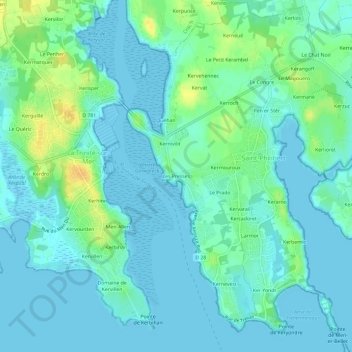
Name: Topografische Karte Les Presses, Höhe, Relief.
Durchschnittliche Höhe: 7 m
Minimale Höhe: -2 m
Maximale Höhe: 28 m
Andere topografische Karten
Klicken Sie auf eine Karte, um ihre Topografie, ihre Höhe und ihr Relief anzuzeigen.
Kerroch
France > Bretagne > Morbihan > Saint-Philibert
Kerroch, Saint-Philibert, Lorient, Morbihan, Bretagne, France métropolitaine, 56470, France
Durchschnittliche Höhe: 9 m
Kermouroux
France > Bretagne > Morbihan > Saint-Philibert
Kermouroux, Saint-Philibert, Lorient, Morbihan, Bretagne, France métropolitaine, 56470, France
Durchschnittliche Höhe: 7 m
Larmor
France > Bretagne > Morbihan > Saint-Philibert
Larmor, Saint-Philibert, Lorient, Morbihan, Bretagne, France métropolitaine, 56470, France
Durchschnittliche Höhe: 5 m
Pen er Stêr
France > Bretagne > Morbihan > Saint-Philibert > Pen er Stêr
Pen er Stêr, Saint-Philibert, Lorient, Morbihan, Bretagne, France métropolitaine, 56470, France
Durchschnittliche Höhe: 8 m
Kerran
France > Bretagne > Morbihan > Saint-Philibert
Kerran, Saint-Philibert, Lorient, Morbihan, Bretagne, France métropolitaine, 56470, France
Durchschnittliche Höhe: 9 m
Kerzuc
France > Bretagne > Morbihan > Saint-Philibert
Kerzuc, Saint-Philibert, Lorient, Morbihan, Bretagne, France métropolitaine, 56470, France
Durchschnittliche Höhe: 8 m
Kerarno
France > Bretagne > Morbihan > Saint-Philibert
Kerarno, Saint-Philibert, Lorient, Morbihan, Bretagne, France métropolitaine, 56470, France
Durchschnittliche Höhe: 5 m
Kernevest
France > Bretagne > Morbihan > Saint-Philibert
Kernevest, Saint-Philibert, Lorient, Morbihan, Bretagne, France métropolitaine, 56470, France
Durchschnittliche Höhe: 3 m