
Topografische Karte Abiul
Interaktive Karte
Klicken Sie auf die Karte, um die Höhe anzuzeigen.
Über diese Karte
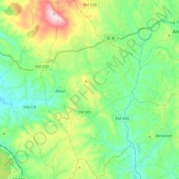
Name: Topografische Karte Abiul, Höhe, Relief.
Ort: Abiul, Pombal, Leiria, Portugal (39.81505 -8.55532 39.93174 -8.46999)
Durchschnittliche Höhe: 233 m
Minimale Höhe: 99 m
Maximale Höhe: 555 m
Andere topografische Karten
Klicken Sie auf eine Karte, um ihre Topografie, ihre Höhe und ihr Relief anzuzeigen.
Matos do Carriço
Portugal > Leiria > Pombal > Carriço
Matos do Carriço, Carriço, Pombal, Leiria, 3105-057, Portugal
Durchschnittliche Höhe: 96 m
Chão do Ulmeiro
Portugal > Leiria > Pombal > Vila Cã
Chão do Ulmeiro, Vila Cã, Pombal, Leiria, Portugal
Durchschnittliche Höhe: 268 m
Vale do Feto
Portugal > Leiria > Pombal > Carnide
Vale do Feto, Carnide, Pombal, Leiria, 3105-253, Portugal
Durchschnittliche Höhe: 150 m
Penedos
Portugal > Leiria > Pombal > Almagreira
Penedos, Almagreira, Pombal, Leiria, 3105-005, Portugal
Durchschnittliche Höhe: 73 m
Vale Pomares
Vale Pomares, Santiago e São Simão de Litém e Albergaria dos Doze, Pombal, Leiria, Portugal
Durchschnittliche Höhe: 246 m
Carramanha
Portugal > Leiria > Pombal > Redinha
Carramanha, Redinha, Pombal, Leiria, 3105, Portugal
Durchschnittliche Höhe: 65 m
Praia do Osso da Baleia
Portugal > Leiria > Pombal > Carriço
Praia do Osso da Baleia, Carriço, Pombal, Leiria, Portugal
Durchschnittliche Höhe: 10 m
Almagreira
Almagreira, Pombal, Leiria, 3105-005, Portugal
Durchschnittliche Höhe: 67 m