Geolokalisieren
👉 Easily get elevation data in JSON, GeoTIFF and KML formats using Elevation API
Vielen Dank für die Unterstützung dieser Website ❤️
Spenden

Topografische Karte Minster

Klicken Sie auf die Karte, um die Höhe anzuzeigen.

Über diese Karte

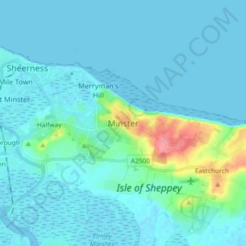
Name: Topografische Karte Minster, Höhe, Relief.

Ort: Minster, Borough of Swale, Kent, England, ME12 3QD, United Kingdom (51.38174 0.77205 51.46174 0.85205)

Durchschnittliche Höhe: 9 m

Minimale Höhe: -3 m

Maximale Höhe: 75 m

Andere topografische Karten

Klicken Sie auf eine Karte, um ihre Topografie, ihre Höhe und ihr Relief anzuzeigen.

The Swale

United Kingdom > England > Kent > Borough of Swale

Durchschnittliche Höhe: 12 m

Minster-on-Sea

United Kingdom > England > Kent > Borough of Swale > Minster

Durchschnittliche Höhe: 8 m

Milstead

United Kingdom > England > Kent > Borough of Swale > Milstead

Durchschnittliche Höhe: 106 m

Borden

United Kingdom > England > Kent > Borough of Swale > Borden

Durchschnittliche Höhe: 64 m

Isle of Sheppey

United Kingdom > England > Kent > Borough of Swale

Durchschnittliche Höhe: 6 m

Lower Halstow

United Kingdom > England > Kent > Borough of Swale

Durchschnittliche Höhe: 12 m

Newington

United Kingdom > England > Kent > Borough of Swale

Durchschnittliche Höhe: 45 m

Bobbing

United Kingdom > England > Kent > Borough of Swale

Durchschnittliche Höhe: 32 m

Newnham

United Kingdom > England > Kent > Borough of Swale > Newnham

Durchschnittliche Höhe: 89 m

Newnham

United Kingdom > England > Kent > Borough of Swale > Newnham

Durchschnittliche Höhe: 89 m

Faversham

United Kingdom > England > Kent > Borough of Swale

Durchschnittliche Höhe: 17 m

Hernhill

United Kingdom > England > Kent > Borough of Swale > Dargate

Durchschnittliche Höhe: 29 m

Sheldwich

United Kingdom > England > Kent > Borough of Swale

Durchschnittliche Höhe: 70 m

Selling

United Kingdom > England > Kent > Borough of Swale

Durchschnittliche Höhe: 64 m

Eastchurch

United Kingdom > England > Kent > Borough of Swale

Durchschnittliche Höhe: 16 m

Stalisfield

United Kingdom > England > Kent > Borough of Swale

Durchschnittliche Höhe: 137 m

Luddenham

United Kingdom > England > Kent > Borough of Swale > Oare

Durchschnittliche Höhe: 7 m

Luddenham

United Kingdom > England > Kent > Borough of Swale

Durchschnittliche Höhe: 7 m

Oare Creek

United Kingdom > England > Kent > Borough of Swale > Faversham > Oare

Durchschnittliche Höhe: 6 m

Boughton under Blean

United Kingdom > England > Kent > Borough of Swale

Durchschnittliche Höhe: 48 m

Faversham

United Kingdom > England > Kent > Borough of Swale > Ospringe

Durchschnittliche Höhe: 17 m

Iwade

United Kingdom > England > Kent > Borough of Swale

Durchschnittliche Höhe: 6 m

Upchurch

United Kingdom > England > Kent > Borough of Swale

Durchschnittliche Höhe: 10 m

Faversham Creek

United Kingdom > England > Kent > Borough of Swale > Faversham > Oare

Durchschnittliche Höhe: 11 m

Bapchild

United Kingdom > England > Kent > Borough of Swale > Bapchild

Durchschnittliche Höhe: 21 m

Faversham Creek

United Kingdom > England > Kent > Borough of Swale > Faversham > Oare

Durchschnittliche Höhe: 8 m

Sheerness

United Kingdom > England > Kent > Borough of Swale

Durchschnittliche Höhe: 3 m

Tonge

United Kingdom > England > Kent > Borough of Swale > Bapchild

Durchschnittliche Höhe: 23 m

Hartlip

United Kingdom > England > Kent > Borough of Swale > Hartlip

Durchschnittliche Höhe: 70 m

Oare

United Kingdom > England > Kent > Borough of Swale > Oare

Durchschnittliche Höhe: 4 m

Queenborough

United Kingdom > England > Kent > Borough of Swale

Durchschnittliche Höhe: 2 m

Lewson Street

United Kingdom > England > Kent > Borough of Swale > Norton

Durchschnittliche Höhe: 36 m

Bredgar

United Kingdom > England > Kent > Borough of Swale

Durchschnittliche Höhe: 100 m

Teynham

United Kingdom > England > Kent > Borough of Swale

Durchschnittliche Höhe: 6 m

Doddington

United Kingdom > England > Kent > Borough of Swale > Doddington

Durchschnittliche Höhe: 103 m

Sheerness

United Kingdom > England > Kent > Borough of Swale

Durchschnittliche Höhe: 3 m

Rüste dich für dein nächstes Abenteuer:

🍲Outdoor‑Geschirrsets - Leichte und robuste Sets für Essen unterwegs
🫖Thermoskannen & Flaschen - Isolierte Flaschen für warme und kalte Getränke
🧺Rucksack Regenhüllen - Schutz vor Nässe für dein Gepäck
🔋Lithium-Batterien - Kälteresistente Batterien für technische Geräte im Winter
🧪Wasser‑Teststreifen - Test zur Sicherstellung von Trinkwasserqualität

Als Amazon-Partner verdient diese Seite an qualifizierten Käufen, ohne dass Ihnen zusätzliche Kosten entstehen.