
Topografische Karte Egham
Klicken Sie auf die Karte, um die Höhe anzuzeigen.
Über diese Karte
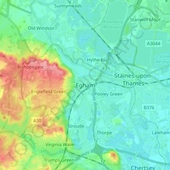
Name: Topografische Karte Egham, Höhe, Relief.
Durchschnittliche Höhe: 29 m
Minimale Höhe: 9 m
Maximale Höhe: 90 m
Andere topografische Karten
Klicken Sie auf eine Karte, um ihre Topografie, ihre Höhe und ihr Relief anzuzeigen.
Addlestone
United Kingdom > England > Surrey > Borough of Runnymede
Elevations range between 11 metres (36 ft) and 40 metres (130 ft). The maximum is on Row Hill recreation ground, Row Town, Addlestone; a ridge that continues to the northwest of Row Town where it is known as Ongar/Spinney Hill, where Great Grove Farm in its centre also reaches this height; the minimum is by…
Durchschnittliche Höhe: 18 m
Chertsey
United Kingdom > England > Surrey > Borough of Runnymede
Samuel Lewis devotes one of his longest entries to the small town in his 1848 topographical guide to England.
Durchschnittliche Höhe: 17 m
Addlestone
United Kingdom > England > Surrey > Borough of Runnymede
Elevations range between 11 and 40 metres (36 and 131 ft). The maximum is on Row Hill recreation ground, Row Town, Addlestone; a ridge that continues to the northwest of Row Town where it is known as Ongar/Spinney Hill, where Great Grove Farm in its centre also reaches this height; the minimum is by the Thames…
Durchschnittliche Höhe: 18 m
Addlestone
United Kingdom > England > Surrey > Borough of Runnymede
Elevations range between 11 metres (36 ft) and 40 metres (130 ft). The maximum is on Row Hill recreation ground, Row Town, Addlestone; a ridge that continues to the northwest of Row Town where it is known as Ongar/Spinney Hill, where Great Grove Farm in its centre also reaches this height; the minimum is by…
Durchschnittliche Höhe: 18 m
Chertsey
United Kingdom > England > Surrey > Borough of Runnymede
Samuel Lewis devotes one of his longest entries to the small town in his 1848 topographical guide to England.
Durchschnittliche Höhe: 17 m
Chertsey
United Kingdom > England > Surrey > Borough of Runnymede
Samuel Lewis devotes one of his longest entries to the small town in his 1848 topographical guide to England.
Durchschnittliche Höhe: 17 m