
Topografische Karte Warsaw
Interaktive Karte
Klicken Sie auf die Karte, um die Höhe anzuzeigen.
Über diese Karte
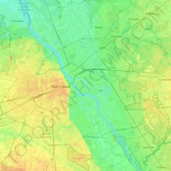
Name: Topografische Karte Warsaw, Höhe, Relief.
Ort: Warsaw, Masovian Voivodeship, Poland (52.09785 20.85169 52.36815 21.27115)
Durchschnittliche Höhe: 96 m
Minimale Höhe: 72 m
Maximale Höhe: 147 m
Warsaw lies in east-central Poland about 300 km (190 mi) from the Carpathian Mountains and about 260 km (160 mi) from the Baltic Sea, 523 km (325 mi) east of Berlin, Germany.[69] The city straddles the Vistula River. It is located in the heartland of the Masovian Plain, and its average elevation is 100 m (330 ft) above sea level. The highest point on the left side of the city lies at a height of 115.7 m (380 ft) ("Redutowa" bus depot, district of Wola), on the right side – 122.1 m (401 ft) ("Groszówka" estate, district of Wesoła, by the eastern border). The lowest point lies at a height 75.6 m (248 ft) (at the right bank of the Vistula, by the eastern border of Warsaw). There are some hills (mostly artificial) located within the confines of the city – e.g. Warsaw Uprising Hill (121 m (397 ft)) and Szczęśliwice hill (138 m (453 ft) – the highest point of Warsaw in general).
Andere topografische Karten
Klicken Sie auf eine Karte, um ihre Topografie, ihre Höhe und ihr Relief anzuzeigen.
Warsaw
Poland > Masovian Voivodeship > Warsaw
Warsaw, Masovian Voivodeship, Poland
Durchschnittliche Höhe: 95 m
Żoliborz
Poland > Masovian Voivodeship > Warsaw
Żoliborz, Warsaw, Masovian Voivodeship, Poland
Durchschnittliche Höhe: 95 m
Śródmieście
Poland > Masovian Voivodeship > Warsaw
Śródmieście, Warsaw, Masovian Voivodeship, Poland
Durchschnittliche Höhe: 101 m
Praga-Południe
Poland > Masovian Voivodeship > Warsaw
Praga-Południe, Warsaw, Warszawa, Masovian Voivodeship, Poland
Durchschnittliche Höhe: 86 m