
Topografische Karte Lightwater
Klicken Sie auf die Karte, um die Höhe anzuzeigen.
Über diese Karte
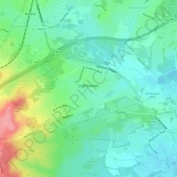
Name: Topografische Karte Lightwater, Höhe, Relief.
Durchschnittliche Höhe: 62 m
Minimale Höhe: 35 m
Maximale Höhe: 130 m
Andere topografische Karten
Klicken Sie auf eine Karte, um ihre Topografie, ihre Höhe und ihr Relief anzuzeigen.
Camberley
United Kingdom > England > Surrey > Surrey Heath
The Staff College, to the north of Camberley town centre, is part of the Joint Services Command and Staff College, which provides training and education for established officers in the British Armed Forces and civil servants in the Ministry of Defence. The institution has its origins in the Royal Military…
Durchschnittliche Höhe: 88 m
Bagshot Park Mansion
United Kingdom > England > Surrey > Surrey Heath > Bagshot
Durchschnittliche Höhe: 76 m
Crawley Hill
United Kingdom > England > Surrey > Surrey Heath > Camberley
Durchschnittliche Höhe: 91 m
Frimley Lodge Park
United Kingdom > England > Surrey > Surrey Heath > Frimley Green
Durchschnittliche Höhe: 80 m
Kalima Caravan Site
United Kingdom > England > Surrey > Surrey Heath > Chobham
Durchschnittliche Höhe: 28 m
Dunstall Green
United Kingdom > England > Surrey > Surrey Heath > Chobham
Durchschnittliche Höhe: 33 m
Camberley
United Kingdom > England > Surrey > Surrey Heath
The Staff College, to the north of Camberley town centre, is part of the Joint Services Command and Staff College, which provides training and education for established officers in the British Armed Forces and civil servants in the Ministry of Defence. The institution has its origins in the Royal Military…
Durchschnittliche Höhe: 88 m