
Topografische Karte Lake Wateree
Interaktive Karte
Klicken Sie auf die Karte, um die Höhe anzuzeigen.
Über diese Karte
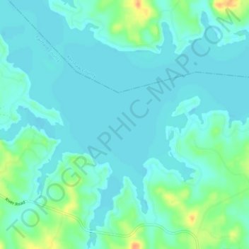
Name: Topografische Karte Lake Wateree, Höhe, Relief.
Ort: Lake Wateree, Kershaw County, South Carolina, United States (34.38781 -80.85292 34.42594 -80.81107)
Durchschnittliche Höhe: 76 m
Minimale Höhe: 67 m
Maximale Höhe: 106 m
Andere topografische Karten
Klicken Sie auf eine Karte, um ihre Topografie, ihre Höhe und ihr Relief anzuzeigen.
Lockhart Oil Field
United States > South Carolina > Kershaw County
Lockhart Oil Field, Kershaw County, South Carolina, United States
Durchschnittliche Höhe: 126 m
White Hills
United States > South Carolina > Kershaw County > Elgin
White Hills, Elgin, Kershaw County, South Carolina, United States
Durchschnittliche Höhe: 97 m
Lugoff
United States > South Carolina > Kershaw County
Lugoff, Kershaw County, South Carolina, United States
Durchschnittliche Höhe: 69 m
Camden
United States > South Carolina > Kershaw County
Camden, Kershaw County, South Carolina, United States
Durchschnittliche Höhe: 68 m
Lake Wateree
United States > South Carolina > Kershaw County
Lake Wateree, Kershaw County, South Carolina, United States
Durchschnittliche Höhe: 109 m
Arrowwood
United States > South Carolina > Kershaw County
Arrowwood, Kershaw County, South Carolina, 29020, United States
Durchschnittliche Höhe: 74 m
Woodland Forest
United States > South Carolina > Kershaw County > Lugoff
Woodland Forest, Lugoff, Kershaw County, South Carolina, 29078, United States
Durchschnittliche Höhe: 65 m
Green Valley
United States > South Carolina > Kershaw County > Green Valley
Green Valley, Kershaw County, South Carolina, United States
Durchschnittliche Höhe: 59 m