
Topografische Karte Sunninghill
Klicken Sie auf die Karte, um die Höhe anzuzeigen.
Über diese Karte
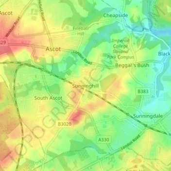
Name: Topografische Karte Sunninghill, Höhe, Relief.
Durchschnittliche Höhe: 67 m
Minimale Höhe: 40 m
Maximale Höhe: 98 m
Andere topografische Karten
Klicken Sie auf eine Karte, um ihre Topografie, ihre Höhe und ihr Relief anzuzeigen.
Windsor Castle
United Kingdom > England > Royal Borough of Windsor and Maidenhead > Windsor > Clewer Village
Durchschnittliche Höhe: 23 m
Windsor Marina
United Kingdom > England > Royal Borough of Windsor and Maidenhead > Oakley Green
Durchschnittliche Höhe: 26 m
Bisham
United Kingdom > England > Royal Borough of Windsor and Maidenhead
Durchschnittliche Höhe: 63 m
Cookham
United Kingdom > England > Royal Borough of Windsor and Maidenhead
Durchschnittliche Höhe: 47 m
Sunningdale
United Kingdom > England > Royal Borough of Windsor and Maidenhead
Durchschnittliche Höhe: 61 m
Wraysbury
United Kingdom > England > Royal Borough of Windsor and Maidenhead
The new chapel, with its elegant slender tower, was opened on 16 October 1862; the building works had cost around £800. The striking terracotta relief panel, The City of Refuge, on the front elevation of the chapel, was created by the renowned Doulton & Co artist George Tinworth and is signed with his…
Durchschnittliche Höhe: 25 m
Waltham St. Lawrence
United Kingdom > England > Royal Borough of Windsor and Maidenhead
Durchschnittliche Höhe: 44 m
White Waltham
United Kingdom > England > Royal Borough of Windsor and Maidenhead
Durchschnittliche Höhe: 41 m
Shottesbrooke
United Kingdom > England > Royal Borough of Windsor and Maidenhead
Durchschnittliche Höhe: 41 m
Magna Carta Island
United Kingdom > England > Royal Borough of Windsor and Maidenhead > Wraysbury
Durchschnittliche Höhe: 32 m
Old Windsor
United Kingdom > England > Royal Borough of Windsor and Maidenhead
Durchschnittliche Höhe: 38 m
Bridge Gardens
United Kingdom > England > Royal Borough of Windsor and Maidenhead > Maidenhead
Durchschnittliche Höhe: 30 m
Hurley
United Kingdom > England > Royal Borough of Windsor and Maidenhead
Durchschnittliche Höhe: 67 m
Upton Court Park
United Kingdom > England > Royal Borough of Windsor and Maidenhead > Slough
Durchschnittliche Höhe: 23 m
Formosa Island
United Kingdom > England > Royal Borough of Windsor and Maidenhead > Cookham
Durchschnittliche Höhe: 48 m
Cox Green
United Kingdom > England > Royal Borough of Windsor and Maidenhead > Maidenhead
Durchschnittliche Höhe: 36 m
Eton Wick
United Kingdom > England > Royal Borough of Windsor and Maidenhead
Durchschnittliche Höhe: 22 m
Horton
United Kingdom > England > Royal Borough of Windsor and Maidenhead > Horton
Durchschnittliche Höhe: 18 m
Windsor Castle
United Kingdom > England > Royal Borough of Windsor and Maidenhead > Windsor > Clewer Village
Durchschnittliche Höhe: 23 m
Windsor Castle
United Kingdom > England > Royal Borough of Windsor and Maidenhead > Windsor > Clewer Village
Durchschnittliche Höhe: 23 m
Sunningdale
United Kingdom > England > Royal Borough of Windsor and Maidenhead
Durchschnittliche Höhe: 61 m
Cookham
United Kingdom > England > Royal Borough of Windsor and Maidenhead
Durchschnittliche Höhe: 47 m
Wraysbury
United Kingdom > England > Royal Borough of Windsor and Maidenhead
The new chapel, with its elegant slender tower, was opened on 16 October 1862; the building works had cost around £800. The striking terracotta relief panel, The City of Refuge, on the front elevation of the chapel, was created by the renowned Doulton & Co artist George Tinworth and is signed with his…
Durchschnittliche Höhe: 26 m
Windsor Castle
United Kingdom > England > Royal Borough of Windsor and Maidenhead > Windsor > Clewer Village
Durchschnittliche Höhe: 23 m