
Topografische Karte Somersworth
Interaktive Karte
Klicken Sie auf die Karte, um die Höhe anzuzeigen.
Über diese Karte
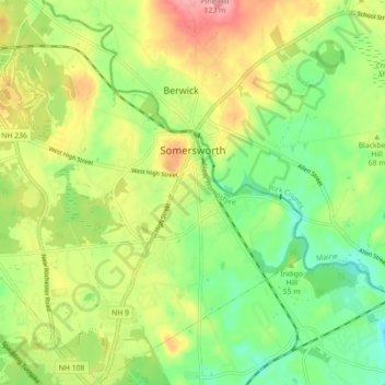
Name: Topografische Karte Somersworth, Höhe, Relief.
Durchschnittliche Höhe: 56 m
Minimale Höhe: 8 m
Maximale Höhe: 120 m
According to the United States Census Bureau, the city has a total area of 10.0 square miles (25.9 km2), of which 9.8 square miles (25.4 km2) are land and 0.2 square miles (0.5 km2) are water, comprising 1.96% of the city. Somersworth is bordered to the northeast by the Salmon Falls River, which is also the state boundary with Maine. The highest point in Somersworth is Prospect Hill rising just west of the city center, on which the city reservoir is built. The hill's elevation is approximately 310 feet (94 m) above sea level.
Andere topografische Karten
Klicken Sie auf eine Karte, um ihre Topografie, ihre Höhe und ihr Relief anzuzeigen.
Rollinsford
United States > New Hampshire > Strafford County
Rollinsford, Strafford County, New Hampshire, 03869, United States
Durchschnittliche Höhe: 32 m
New Durham
United States > New Hampshire > Strafford County
New Durham, Strafford County, New Hampshire, 03855, United States
Durchschnittliche Höhe: 228 m
Dover
United States > New Hampshire > Strafford County
Dover, Strafford County, New Hampshire, 03820, United States
Durchschnittliche Höhe: 31 m
Dover
United States > New Hampshire > Strafford County > Dover
Dover, Strafford County, New Hampshire, 03820, United States
Durchschnittliche Höhe: 52 m
Lee
United States > New Hampshire > Strafford County
Lee, Strafford County, New Hampshire, 03861, United States
Durchschnittliche Höhe: 47 m
Rochester
United States > New Hampshire > Strafford County > Rochester
Rochester, Strafford County, New Hampshire, United States
Durchschnittliche Höhe: 90 m