
Topografische Karte More
Klicken Sie auf die Karte, um die Höhe anzuzeigen.
Über diese Karte
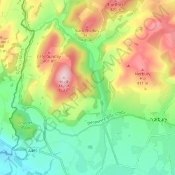
Name: Topografische Karte More, Höhe, Relief.
Ort: More, Shropshire, England, United Kingdom (52.51420 -3.00407 52.56125 -2.94112)
Durchschnittliche Höhe: 264 m
Minimale Höhe: 141 m
Maximale Höhe: 449 m
Andere topografische Karten
Klicken Sie auf eine Karte, um ihre Topografie, ihre Höhe und ihr Relief anzuzeigen.
Minton
United Kingdom > England > Shropshire > Church Stretton > Little Stretton
Durchschnittliche Höhe: 272 m
Cothercott Hill
United Kingdom > England > Shropshire > Church Pulverbatch
Durchschnittliche Höhe: 342 m