
Topografische Karte Three Sisters
Interaktive Karte
Klicken Sie auf die Karte, um die Höhe anzuzeigen.
Über diese Karte
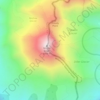
Name: Topografische Karte Three Sisters, Höhe, Relief.
Ort: Three Sisters, Deschutes County, Oregon, United States (44.14716 -121.78299 44.14726 -121.78289)
Durchschnittliche Höhe: 2’526 m
Minimale Höhe: 2’164 m
Maximale Höhe: 3’046 m
The Three Sisters are closely spaced volcanic peaks in the U.S. state of Oregon. They are part of the Cascade Volcanic Arc, a segment of the Cascade Range in western North America extending from southern British Columbia through Washington and Oregon to Northern California. Each more than 10,000 feet (3,000 m) in elevation, they are the third-, fourth- and fifth-highest peaks in Oregon. Located in the Three Sisters Wilderness at the boundary of Lane and Deschutes counties and the Willamette and Deschutes national forests, they are about 10 miles (16 km) south of the nearest town, Sisters. Diverse species of flora and fauna inhabit the area, which is subject to frequent snowfall, occasional rain, and extreme temperature variation between seasons. The mountains, particularly South Sister, are popular destinations for climbing and scrambling.
Andere topografische Karten
Klicken Sie auf eine Karte, um ihre Topografie, ihre Höhe und ihr Relief anzuzeigen.
Bend
United States > Oregon > Deschutes County
Bend, Deschutes County, Oregon, United States
Durchschnittliche Höhe: 1’121 m
Sunriver
United States > Oregon > Deschutes County
Sunriver, Deschutes County, Oregon, 97707, United States
Durchschnittliche Höhe: 1’312 m
Redmond
United States > Oregon > Deschutes County
Redmond, Deschutes County, Oregon, 91156, United States
Durchschnittliche Höhe: 923 m
La Pine
United States > Oregon > Deschutes County
La Pine, Deschutes County, Oregon, 97739, United States
Durchschnittliche Höhe: 1’290 m
Anns Butte
United States > Oregon > Deschutes County
Anns Butte, Deschutes County, Oregon, United States
Durchschnittliche Höhe: 1’312 m
Sisters
United States > Oregon > Deschutes County
Sisters, Deschutes County, Oregon, United States
Durchschnittliche Höhe: 973 m
Archie Briggs Canyon Natural Area
United States > Oregon > Deschutes County > Bend
Archie Briggs Canyon Natural Area, Northwest Falcon Ridge, Bend, Deschutes County, Oregon, 97703, United States
Durchschnittliche Höhe: 1’115 m
Three Rivers
United States > Oregon > Deschutes County > Sunriver
Three Rivers, Sunriver, Deschutes County, Oregon, United States
Durchschnittliche Höhe: 1’296 m
Lava Butte
United States > Oregon > Deschutes County
Lava Butte, Deschutes County, Oregon, United States
Durchschnittliche Höhe: 1’365 m
Smith Rock State Park
United States > Oregon > Deschutes County > Terrebonne
Smith Rock State Park, 9241, Northeast Crooked River Drive, Terrebonne, Deschutes County, Oregon, 97760, United States
Durchschnittliche Höhe: 875 m
Terrebonne
United States > Oregon > Deschutes County > Terrebonne
Terrebonne, Deschutes County, Oregon, United States
Durchschnittliche Höhe: 855 m
Tumalo Falls
United States > Oregon > Deschutes County
Tumalo Falls, Deschutes County, Oregon, United States
Durchschnittliche Höhe: 1’656 m
Deschutes River Woods
United States > Oregon > Deschutes County
Deschutes River Woods, Deschutes County, Oregon, United States
Durchschnittliche Höhe: 1’210 m
Vista Butte
United States > Oregon > Deschutes County
Vista Butte, Deschutes County, Oregon, United States
Durchschnittliche Höhe: 1’864 m
Crane Prairie Reservoir
United States > Oregon > Deschutes County
Crane Prairie Reservoir, Deschutes County, Oregon, United States
Durchschnittliche Höhe: 1’375 m
Brothers
United States > Oregon > Deschutes County
Brothers, Deschutes County, Oregon, United States
Durchschnittliche Höhe: 1’410 m
Mount Bachelor
United States > Oregon > Deschutes County
Mount Bachelor, Deschutes County, Oregon, United States
Durchschnittliche Höhe: 2’327 m
Pilot Butte
United States > Oregon > Deschutes County > Bend
Pilot Butte, Bend, Deschutes County, Oregon, 97701, United States
Durchschnittliche Höhe: 1’113 m