
Topografische Karte Fort Collins
Interaktive Karte
Klicken Sie auf die Karte, um die Höhe anzuzeigen.
Über diese Karte
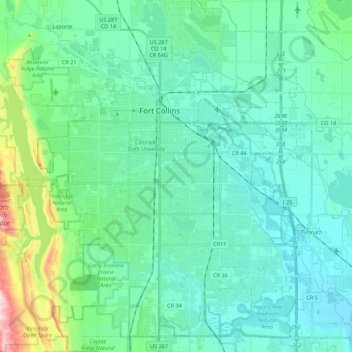
Name: Topografische Karte Fort Collins, Höhe, Relief.
Ort: Fort Collins, Larimer County, Colorado, United States (40.47261 -105.15736 40.63935 -104.98200)
Durchschnittliche Höhe: 1’548 m
Minimale Höhe: 1’462 m
Maximale Höhe: 1’956 m
Fort Collins is situated at the base of the Rocky Mountain foothills of the northern Front Range, approximately 60 miles (97 km) north of Denver, Colorado, and 45 miles (72 km) south of Cheyenne, Wyoming. Elevation is 4,982 ft (1,519 m) above sea level. Geographic landmarks include Horsetooth Reservoir and Horsetooth Mountain—so named because of a tooth-shaped granite rock that dominates the city's western skyline. Longs Peak can also clearly be seen on a clear day to the southwest of the city.
Andere topografische Karten
Klicken Sie auf eine Karte, um ihre Topografie, ihre Höhe und ihr Relief anzuzeigen.
Estes Park
United States > Colorado > Larimer County
Estes Park, Larimer County, Colorado, 80517, United States
Durchschnittliche Höhe: 2’430 m
Timnath
United States > Colorado > Larimer County
Timnath, Larimer County, Colorado, 80547, United States
Durchschnittliche Höhe: 1’493 m
Estes Park
United States > Colorado > Larimer County
Estes Park, Larimer County, Colorado, United States
Durchschnittliche Höhe: 2’409 m
Mount Evelyn
United States > Colorado > Larimer County
Mount Evelyn, Larimer County, Colorado, United States
Durchschnittliche Höhe: 2’206 m