
Topografische Karte Poteau
Interaktive Karte
Klicken Sie auf die Karte, um die Höhe anzuzeigen.
Über diese Karte
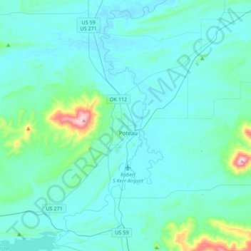
Name: Topografische Karte Poteau, Höhe, Relief.
Ort: Poteau, Le Flore County, Oklahoma, 74953, United States (34.92772 -94.73447 35.20218 -94.57137)
Durchschnittliche Höhe: 189 m
Minimale Höhe: 125 m
Maximale Höhe: 770 m
The city is located in the valley below Cavanal Hill, dubbed the "World's Highest Hill" with a signed elevation of 1,999 feet (609 m). The location was a subject of extensive coal mining in the first half of the 20th Century, and a railway, eventually called the Poteau and Cavanal Mountain Railroad, served the mines. The summit elevation of the hill is 2,385 feet (727 m) above sea level, while the hill rises 1,960 feet (600 m) above the Poteau River on the east side of Poteau. The Poteau River is the only river in Oklahoma that flows north. It flows into Arkansas where it meets the Arkansas River at Belle Point in Fort Smith.
Andere topografische Karten
Klicken Sie auf eine Karte, um ihre Topografie, ihre Höhe und ihr Relief anzuzeigen.
Heavener
United States > Oklahoma > Le Flore County
Heavener, Le Flore County, Oklahoma, 74937, United States
Durchschnittliche Höhe: 193 m
Talimena State Park
United States > Oklahoma > Le Flore County
Talimena State Park, Le Flore County, Oklahoma, United States
Durchschnittliche Höhe: 345 m