
Topografische Karte Middleton
Klicken Sie auf die Karte, um die Höhe anzuzeigen.
Über diese Karte
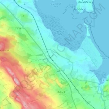
Name: Topografische Karte Middleton, Höhe, Relief.
Ort: Middleton, Northumberland, North East, England, United Kingdom (55.59793 -1.90907 55.66291 -1.73662)
Durchschnittliche Höhe: 45 m
Minimale Höhe: -1 m
Maximale Höhe: 204 m
Andere topografische Karten
Klicken Sie auf eine Karte, um ihre Topografie, ihre Höhe und ihr Relief anzuzeigen.
Throckley
United Kingdom > England > Northumberland > Newcastle upon Tyne
Durchschnittliche Höhe: 65 m
Amble
United Kingdom > England > Northumberland
Samuel Lewis reported a township population of 247 in 1831. By the seventh edition of his Topographical Dictionary of England, which was published in 1848, this figure had risen to 724. The population was reported as being 1,040 in 1851. The 1871 census recorded a population of 1,233, spread among 233 houses.
Durchschnittliche Höhe: 15 m
Styford Wood
United Kingdom > England > Northumberland > Riding Mill > Bywell
Durchschnittliche Höhe: 64 m
Aydon Castle
United Kingdom > England > Northumberland > Corbridge > Aydon
Durchschnittliche Höhe: 121 m
Sharp Law
United Kingdom > England > Northumberland > Crookham > Crookham Eastfield
Durchschnittliche Höhe: 56 m
Berwick
United Kingdom > England > Northumberland > Berwick-upon-Tweed > Spittal
Durchschnittliche Höhe: 8 m
North Hazelrigg
United Kingdom > England > Northumberland > Chatton > North Hazelrigg
Durchschnittliche Höhe: 99 m
Whittingham Station
United Kingdom > England > Northumberland > Whittingham
Durchschnittliche Höhe: 85 m