
Spenden
Rüste dich für dein nächstes Abenteuer:
Als Amazon-Partner verdient diese Seite an qualifizierten Käufen, ohne dass Ihnen zusätzliche Kosten entstehen.
Topografische Karte Mullan
Klicken Sie auf die Karte, um die Höhe anzuzeigen.
Spenden
Rüste dich für dein nächstes Abenteuer:
Als Amazon-Partner verdient diese Seite an qualifizierten Käufen, ohne dass Ihnen zusätzliche Kosten entstehen.
Mullan
In Shoshone County at the east end of the Silver Valley, Mullan is in a sheltered canyon of the Coeur d'Alene Mountains at an elevation of 3,278 feet (1,000 m) above sea level. The entrance to the Lucky Friday mine is several hundred yards east of the city center; the active mine (silver, lead, & zinc) descends more than six thousand feet (1.1 mi; 1.8 km) below the surface.
Spenden
Rüste dich für dein nächstes Abenteuer:
Als Amazon-Partner verdient diese Seite an qualifizierten Käufen, ohne dass Ihnen zusätzliche Kosten entstehen.
Über diese Karte
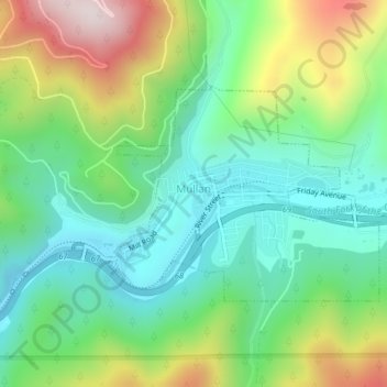
Name: Topografische Karte Mullan, Höhe, Relief.
Ort: Mullan, Shoshone County, Idaho, 83846, United States (47.46237 -115.81073 47.47740 -115.78263)
Durchschnittliche Höhe: 1’168 m
Minimale Höhe: 962 m
Maximale Höhe: 1’577 m
Spenden
Rüste dich für dein nächstes Abenteuer:
Als Amazon-Partner verdient diese Seite an qualifizierten Käufen, ohne dass Ihnen zusätzliche Kosten entstehen.
Andere topografische Karten
Klicken Sie auf eine Karte, um ihre Topografie, ihre Höhe und ihr Relief anzuzeigen.
Burke
United States > Idaho > Shoshone County > Mace
Burke is located about 7 miles (11 km) northeast of Wallace, at an elevation of 3,700 feet (1,130 m) above sea level. It is accessed from Wallace on Burke-Canyon Creek Road (State Highway 4). The town is located approximately 100 miles (160 km) south of the Canadian province of British Columbia, and roughly 5…
Durchschnittliche Höhe: 1’459 m
Spenden
Rüste dich für dein nächstes Abenteuer:
Als Amazon-Partner verdient diese Seite an qualifizierten Käufen, ohne dass Ihnen zusätzliche Kosten entstehen.
Spenden
Rüste dich für dein nächstes Abenteuer:
Als Amazon-Partner verdient diese Seite an qualifizierten Käufen, ohne dass Ihnen zusätzliche Kosten entstehen.
Spenden
Rüste dich für dein nächstes Abenteuer:
Als Amazon-Partner verdient diese Seite an qualifizierten Käufen, ohne dass Ihnen zusätzliche Kosten entstehen.