
Topografische Karte Afognak Island
Interaktive Karte
Klicken Sie auf die Karte, um die Höhe anzuzeigen.
Über diese Karte
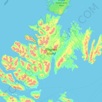
Name: Topografische Karte Afognak Island, Höhe, Relief.
Ort: Afognak Island, Kodiak Island, Alaska, United States (57.98953 -153.22385 58.48253 -151.96273)
Durchschnittliche Höhe: 71 m
Minimale Höhe: -4 m
Maximale Höhe: 731 m
Andere topografische Karten
Klicken Sie auf eine Karte, um ihre Topografie, ihre Höhe und ihr Relief anzuzeigen.
Kodiak
United States > Alaska > Kodiak Island
Kodiak, Kodiak Island, Alaska, United States
Durchschnittliche Höhe: 67 m
Kodiak Station
United States > Alaska > Kodiak Island > Kodiak
Kodiak Station, Kodiak, Kodiak Island, Alaska, 99619, United States
Durchschnittliche Höhe: 105 m
Kodiak
United States > Alaska > Kodiak Island
Kodiak, Kodiak Island, Alaska, United States
Durchschnittliche Höhe: 62 m
Olga Bay
United States > Alaska > Kodiak Island
Olga Bay, Kodiak Island, Alaska, United States
Durchschnittliche Höhe: 81 m
Chiniak
United States > Alaska > Kodiak Island
Chiniak, Kodiak Island, Alaska, United States
Durchschnittliche Höhe: 86 m
Karluk
United States > Alaska > Kodiak Island
Karluk, Kodiak Island, Alaska, 99608, United States
Durchschnittliche Höhe: 126 m