
Topografische Karte Hoshiarpur
Klicken Sie auf die Karte, um die Höhe anzuzeigen.
Hoshiarpur
Hoshiarpur has an average elevation of 296 metres (971 ft). Hoshiarpur district is located in the north-east part of the Indian state of Punjab. It falls in the Jalandhar Revenue Division and is situated in the Bist Doab portion of the Doaba region. Hoshiarpur shares a boundary with Kangra district, and Una district of Himachal Pradesh in the northeast. In the southwest, it borders Shahid Bhagat Singh Nagar district, Jalandhar district, and Kapurthala district, and in the northwest it borders Gurdaspur district.
Über diese Karte
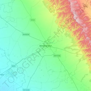
Name: Topografische Karte Hoshiarpur, Höhe, Relief.
Durchschnittliche Höhe: 327 m
Minimale Höhe: 239 m
Maximale Höhe: 613 m