
Topografische Karte Lees Lick
Interaktive Karte
Klicken Sie auf die Karte, um die Höhe anzuzeigen.
Über diese Karte
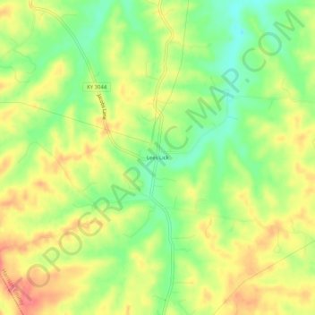
Name: Topografische Karte Lees Lick, Höhe, Relief.
Ort: Lees Lick, Harrison County, Kentucky, United States (38.31591 -84.43855 38.35591 -84.39855)
Durchschnittliche Höhe: 265 m
Minimale Höhe: 230 m
Maximale Höhe: 299 m
Andere topografische Karten
Klicken Sie auf eine Karte, um ihre Topografie, ihre Höhe und ihr Relief anzuzeigen.
Boyd
United States > Kentucky > Harrison County
Boyd, Harrison County, Kentucky, 41003, United States
Durchschnittliche Höhe: 214 m
Leesburg
United States > Kentucky > Harrison County
Leesburg, Harrison County, Kentucky, United States
Durchschnittliche Höhe: 280 m
Broadwell
United States > Kentucky > Harrison County
Broadwell, Harrison County, Kentucky, United States
Durchschnittliche Höhe: 264 m
Berry
United States > Kentucky > Harrison County
Berry, Harrison County, Kentucky, 41003, United States
Durchschnittliche Höhe: 211 m
Connersville
United States > Kentucky > Harrison County
Connersville, Harrison County, Kentucky, United States
Durchschnittliche Höhe: 256 m
Rutland
United States > Kentucky > Harrison County
Rutland, Harrison County, Kentucky, United States
Durchschnittliche Höhe: 256 m
Buena Vista
United States > Kentucky > Harrison County
Buena Vista, Harrison County, Kentucky, United States
Durchschnittliche Höhe: 247 m
Claysville
United States > Kentucky > Harrison County
Claysville, Harrison County, Kentucky, United States
Durchschnittliche Höhe: 209 m
Colemansville
United States > Kentucky > Harrison County
Colemansville, Harrison County, Kentucky, 41003, United States
Durchschnittliche Höhe: 217 m
Lair
United States > Kentucky > Harrison County
Lair, Harrison County, Kentucky, 41031, United States
Durchschnittliche Höhe: 246 m
Antioch
United States > Kentucky > Harrison County
Antioch, Harrison County, Kentucky, United States
Durchschnittliche Höhe: 233 m
Colville
United States > Kentucky > Harrison County
Colville, Harrison County, Kentucky, United States
Durchschnittliche Höhe: 266 m
Robinson
United States > Kentucky > Harrison County
Robinson, Harrison County, Kentucky, 41003, United States
Durchschnittliche Höhe: 221 m
Oddville
United States > Kentucky > Harrison County
Oddville, Harrison County, Kentucky, United States
Durchschnittliche Höhe: 258 m
Kelat
United States > Kentucky > Harrison County
Kelat, Harrison County, Kentucky, United States
Durchschnittliche Höhe: 256 m
Cynthiana
United States > Kentucky > Harrison County
Cynthiana, Harrison County, Kentucky, 41031, United States
Durchschnittliche Höhe: 238 m