
Topografische Karte Gaithersburg
Interaktive Karte
Klicken Sie auf die Karte, um die Höhe anzuzeigen.
Über diese Karte
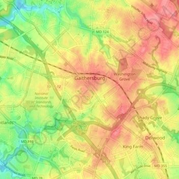
Name: Topografische Karte Gaithersburg, Höhe, Relief.
Ort: Gaithersburg, Montgomery County, Maryland, United States (39.10275 -77.25827 39.16831 -77.17118)
Durchschnittliche Höhe: 137 m
Minimale Höhe: 93 m
Maximale Höhe: 171 m
Andere topografische Karten
Klicken Sie auf eine Karte, um ihre Topografie, ihre Höhe und ihr Relief anzuzeigen.
Forest Glen
United States > Maryland > Montgomery County > Forest Glen > McKenney Hills
Forest Glen, McKenney Hills, Forest Glen, Montgomery County, Maryland, United States
Durchschnittliche Höhe: 105 m
Forest Glen
United States > Maryland > Montgomery County
Forest Glen, Montgomery County, Maryland, 20895, United States
Durchschnittliche Höhe: 96 m
Rockville
United States > Maryland > Montgomery County
Rockville, Montgomery County, Maryland, United States
Durchschnittliche Höhe: 122 m
Germantown
United States > Maryland > Montgomery County > Germantown
Germantown, Montgomery County, Maryland, United States
Durchschnittliche Höhe: 130 m
Redland
United States > Maryland > Montgomery County
Redland, Montgomery County, Maryland, 20855, United States
Durchschnittliche Höhe: 139 m
Damascus
United States > Maryland > Montgomery County > Damascus
Damascus, Montgomery County, Maryland, 20872, United States
Durchschnittliche Höhe: 195 m