
Topografische Karte Knoxville
Interaktive Karte
Klicken Sie auf die Karte, um die Höhe anzuzeigen.
Über diese Karte
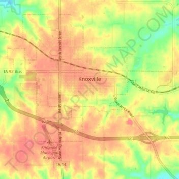
Name: Topografische Karte Knoxville, Höhe, Relief.
Ort: Knoxville, Marion County, Iowa, United States (41.29178 -93.13108 41.33852 -93.05724)
Durchschnittliche Höhe: 265 m
Minimale Höhe: 226 m
Maximale Höhe: 288 m
Andere topografische Karten
Klicken Sie auf eine Karte, um ihre Topografie, ihre Höhe und ihr Relief anzuzeigen.
Pella
United States > Iowa > Marion County
Pella, Marion County, Iowa, United States
Durchschnittliche Höhe: 254 m
Pella
United States > Iowa > Marion County > Pella
Pella, Marion County, Iowa, 50219, United States
Durchschnittliche Höhe: 253 m
Pleasantville
United States > Iowa > Marion County > Pleasantville
Pleasantville, Marion County, Iowa, 50225, United States
Durchschnittliche Höhe: 271 m
Pleasantville
United States > Iowa > Marion County
Pleasantville, Marion County, Iowa, 50225, United States
Durchschnittliche Höhe: 274 m