
Topografische Karte Campo Imperatore
Interaktive Karte
Klicken Sie auf die Karte, um die Höhe anzuzeigen.
Über diese Karte
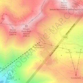
Name: Topografische Karte Campo Imperatore, Höhe, Relief.
Ort: Campo Imperatore, L'Aquila, Abruzzo, Italy (42.43305 13.54872 42.45305 13.56872)
Durchschnittliche Höhe: 2’056 m
Minimale Höhe: 1’359 m
Maximale Höhe: 2’476 m
The plateau's altitude ranges from 1,500 to 1,900 meters. It covers an expanse of approximately 80 km². Campo Imperatore is home to one of Italy's oldest alpine ski resorts. Located on the plateau's western edge, the resort began commercial operation in the 1920s and continues to thrive as a ski resort to this day due to its proximity to Rome (132 km). The resort's hotel became dictator Benito Mussolini's prison in August 1943 with his fall from power until he was freed by German commandos on 12 September 1943. On the eastern side of the plateau is a 4 km cross country ski trail, which is maintained by the nearby town of Castel del Monte.
Andere topografische Karten
Klicken Sie auf eine Karte, um ihre Topografie, ihre Höhe und ihr Relief anzuzeigen.
Fonte Cerreto
Italy > Abruzzo > L'Aquila > L'Aquila
Fonte Cerreto, L'Aquila, Abruzzo, Italy
Durchschnittliche Höhe: 1’329 m
Apennine Mountains
Italy > Abruzzo > L'Aquila > L'Aquila
Apennine Mountains, L'Aquila, Abruzzo, Italy
Durchschnittliche Höhe: 1’735 m