
Topografische Karte Bundschen - Ponticino
Interaktive Karte
Klicken Sie auf die Karte, um die Höhe anzuzeigen.
Über diese Karte
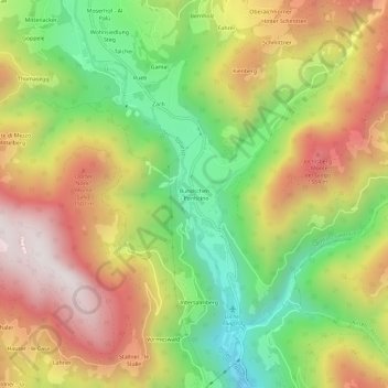
Name: Topografische Karte Bundschen - Ponticino, Höhe, Relief.
Durchschnittliche Höhe: 1’215 m
Minimale Höhe: 711 m
Maximale Höhe: 1’746 m
Andere topografische Karten
Klicken Sie auf eine Karte, um ihre Topografie, ihre Höhe und ihr Relief anzuzeigen.
Weissenbach - Rio Bianco
Italy > Trentino-Alto Adige/Südtirol > South Tyrol > Sarntal - Sarentino
Weissenbach - Rio Bianco, Sarntal - Sarentino, Salten-Schlern - Salto-Sciliar, South Tyrol, Trentino-Alto Adige/Südtirol, Italy
Durchschnittliche Höhe: 1’716 m
Heiss
Italy > Trentino-Alto Adige/Südtirol > South Tyrol > Sarntal - Sarentino > Weissenbach - Rio Bianco
Heiss, Weissenbach - Rio Bianco, Sarntal - Sarentino, Salten-Schlern - Salto-Sciliar, South Tyrol, Trentino-Alto Adige/Südtirol, Italy
Durchschnittliche Höhe: 1’686 m