
Topografische Karte Walnut Cove
Interaktive Karte
Klicken Sie auf die Karte, um die Höhe anzuzeigen.
Über diese Karte
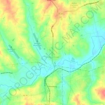
Name: Topografische Karte Walnut Cove, Höhe, Relief.
Ort: Walnut Cove, Stokes County, North Carolina, United States (36.27498 -80.15314 36.31956 -80.12946)
Durchschnittliche Höhe: 206 m
Minimale Höhe: 179 m
Maximale Höhe: 243 m
Andere topografische Karten
Klicken Sie auf eine Karte, um ihre Topografie, ihre Höhe und ihr Relief anzuzeigen.
Hanging Rock
United States > North Carolina > Stokes County
Hanging Rock, Stokes County, North Carolina, United States
Durchschnittliche Höhe: 461 m
Dalton
United States > North Carolina > Stokes County
Dalton, Stokes County, North Carolina, United States
Durchschnittliche Höhe: 287 m
Danbury
United States > North Carolina > Stokes County > Danbury
Danbury, Stokes County, North Carolina, United States
Durchschnittliche Höhe: 264 m
King
United States > North Carolina > Stokes County > King
King, Stokes County, North Carolina, United States
Durchschnittliche Höhe: 308 m
Shelton Store
United States > North Carolina > Stokes County > Shelton Store
Shelton Store, Stokes County, North Carolina, 27046, United States
Durchschnittliche Höhe: 323 m