
Spenden
Rüste dich für dein nächstes Abenteuer:
Als Amazon-Partner verdient diese Seite an qualifizierten Käufen, ohne dass Ihnen zusätzliche Kosten entstehen.
Topografische Karte Mountlake Terrace
Klicken Sie auf die Karte, um die Höhe anzuzeigen.
Spenden
Rüste dich für dein nächstes Abenteuer:
Als Amazon-Partner verdient diese Seite an qualifizierten Käufen, ohne dass Ihnen zusätzliche Kosten entstehen.
Mountlake Terrace
The city sits on a plateau that is elevated from the surrounding landscape, with views of the Olympic and Cascade mountains. The Mountlake Terrace's elevation ranges from 263 to 528 feet (80 to 161 m) above sea level, with an average altitude of 440 feet (130 m). The southwestern portion of the city includes the 100-acre (40 ha) Lake Ballinger, which is fed by Hall Creek from Lynnwood and discharges into McAleer Creek towards Lake Washington. Other portions of Mountlake Terrace lie in the watersheds of Lyon Creek and Swamp Creek, which both drain into Lake Washington.
Spenden
Rüste dich für dein nächstes Abenteuer:
Als Amazon-Partner verdient diese Seite an qualifizierten Käufen, ohne dass Ihnen zusätzliche Kosten entstehen.
Über diese Karte
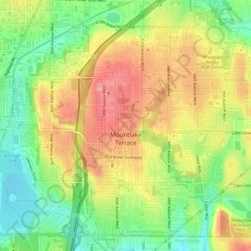
Name: Topografische Karte Mountlake Terrace, Höhe, Relief.
Durchschnittliche Höhe: 121 m
Minimale Höhe: 77 m
Maximale Höhe: 162 m
Spenden
Rüste dich für dein nächstes Abenteuer:
Als Amazon-Partner verdient diese Seite an qualifizierten Käufen, ohne dass Ihnen zusätzliche Kosten entstehen.
Andere topografische Karten
Klicken Sie auf eine Karte, um ihre Topografie, ihre Höhe und ihr Relief anzuzeigen.
Northwest Snohomish
United States > Washington > Snohomish County > Snohomish
Durchschnittliche Höhe: 52 m
Spenden
Rüste dich für dein nächstes Abenteuer:
Als Amazon-Partner verdient diese Seite an qualifizierten Käufen, ohne dass Ihnen zusätzliche Kosten entstehen.
Glacier Peak
United States > Washington > Snohomish County
Despite its elevation of 10,541 feet (3,213 m), Glacier Peak is a small stratovolcano. Its relatively high summit is a consequence of its location atop a high ridge, but its volcanic portion extends only 1,600–3,200 feet (500–1,000 m) above the underlying ridge. Another Cascade Arc volcano with similar…
Durchschnittliche Höhe: 2’656 m
Spenden
Rüste dich für dein nächstes Abenteuer:
Als Amazon-Partner verdient diese Seite an qualifizierten Käufen, ohne dass Ihnen zusätzliche Kosten entstehen.
Bridal Veil Falls-Lower East Cascade
United States > Washington > Snohomish County
Durchschnittliche Höhe: 621 m
Spenden
Rüste dich für dein nächstes Abenteuer:
Als Amazon-Partner verdient diese Seite an qualifizierten Käufen, ohne dass Ihnen zusätzliche Kosten entstehen.
Whitehorse Mountain
United States > Washington > Snohomish County
Whitehorse Mountain is a peak near the western edge of the North Cascades in Washington state. It is located just southwest of the Sauk River Valley town of Darrington, near the northern boundary of Boulder River Wilderness in Mount Baker-Snoqualmie National Forest. While not of particularly high absolute…
Durchschnittliche Höhe: 1’430 m
Lynnwood
United States > Washington > Snohomish County > Lynnwood > Lynnwood
Durchschnittliche Höhe: 112 m
Spenden
Rüste dich für dein nächstes Abenteuer:
Als Amazon-Partner verdient diese Seite an qualifizierten Käufen, ohne dass Ihnen zusätzliche Kosten entstehen.
Mill Creek
United States > Washington > Snohomish County > Mill Creek > Mill Creek
Durchschnittliche Höhe: 129 m
Spenden
Rüste dich für dein nächstes Abenteuer:
Als Amazon-Partner verdient diese Seite an qualifizierten Käufen, ohne dass Ihnen zusätzliche Kosten entstehen.