
Topografische Karte Yardley Gobion
Interaktive Karte
Klicken Sie auf die Karte, um die Höhe anzuzeigen.
Über diese Karte
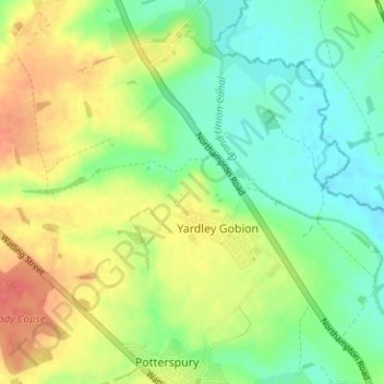
Name: Topografische Karte Yardley Gobion, Höhe, Relief.
Durchschnittliche Höhe: 89 m
Minimale Höhe: 65 m
Maximale Höhe: 123 m
Andere topografische Karten
Klicken Sie auf eine Karte, um ihre Topografie, ihre Höhe und ihr Relief anzuzeigen.
Bengal
United Kingdom > England > South Northamptonshire > Greens Norton > Bengal
Bengal, Greens Norton, South Northamptonshire, Northamptonshire, East Midlands, England, NN12 8BG, United Kingdom
Durchschnittliche Höhe: 112 m
Nether Heyford
United Kingdom > England > South Northamptonshire > Nether Heyford
Nether Heyford, South Northamptonshire, Northamptonshire, East Midlands, England, NN7 3LE, United Kingdom
Durchschnittliche Höhe: 95 m
Adstone
United Kingdom > England > South Northamptonshire
Adstone, South Northamptonshire, Northamptonshire, East Midlands, England, United Kingdom
Durchschnittliche Höhe: 150 m
South Northamptonshire
United Kingdom > England > South Northamptonshire
South Northamptonshire, West Northamptonshire, East Midlands, England, United Kingdom
Durchschnittliche Höhe: 115 m
Deanshanger
United Kingdom > England > South Northamptonshire
Deanshanger, South Northamptonshire, Northamptonshire, East Midlands, England, United Kingdom
Durchschnittliche Höhe: 87 m
Whittlebury
United Kingdom > England > South Northamptonshire
Whittlebury, South Northamptonshire, Northamptonshire, East Midlands, England, United Kingdom
Durchschnittliche Höhe: 126 m
Greatworth
United Kingdom > England > South Northamptonshire
Greatworth, South Northamptonshire, Northamptonshire, East Midlands, England, United Kingdom
Durchschnittliche Höhe: 146 m