
Topografische Karte Rathbun
Interaktive Karte
Klicken Sie auf die Karte, um die Höhe anzuzeigen.
Über diese Karte
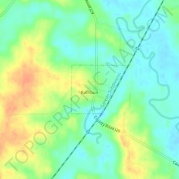
Name: Topografische Karte Rathbun, Höhe, Relief.
Ort: Rathbun, Appanoose County, Iowa, United States (40.79785 -92.89243 40.80524 -92.88127)
Durchschnittliche Höhe: 277 m
Minimale Höhe: 260 m
Maximale Höhe: 302 m
Andere topografische Karten
Klicken Sie auf eine Karte, um ihre Topografie, ihre Höhe und ihr Relief anzuzeigen.
Udell
United States > Iowa > Appanoose County
Udell, Appanoose County, Iowa, United States
Durchschnittliche Höhe: 298 m
Exline
United States > Iowa > Appanoose County
Exline, Appanoose County, Iowa, United States
Durchschnittliche Höhe: 301 m
Numa
United States > Iowa > Appanoose County
Numa, Appanoose County, Iowa, United States
Durchschnittliche Höhe: 303 m
Unionville
United States > Iowa > Appanoose County
Unionville, Appanoose County, Iowa, United States
Durchschnittliche Höhe: 284 m
Plano
United States > Iowa > Appanoose County
Plano, Appanoose County, Iowa, United States
Durchschnittliche Höhe: 308 m
Cincinnati
United States > Iowa > Appanoose County
Cincinnati, Appanoose County, Iowa, United States
Durchschnittliche Höhe: 308 m
Mystic
United States > Iowa > Appanoose County
Mystic, Appanoose County, Iowa, United States
Durchschnittliche Höhe: 292 m
Moravia
United States > Iowa > Appanoose County
Moravia, Appanoose County, Iowa, United States
Durchschnittliche Höhe: 300 m
Centerville
United States > Iowa > Appanoose County
Centerville, Appanoose County, Iowa, 52544, United States
Durchschnittliche Höhe: 293 m