
Topografische Karte Lemon Hill
Interaktive Karte
Klicken Sie auf die Karte, um die Höhe anzuzeigen.
Über diese Karte
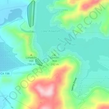
Name: Topografische Karte Lemon Hill, Höhe, Relief.
Ort: Lemon Hill, Tulare County, California, United States (36.40657 -118.99682 36.40667 -118.99672)
Durchschnittliche Höhe: 236 m
Minimale Höhe: 155 m
Maximale Höhe: 448 m
Andere topografische Karten
Klicken Sie auf eine Karte, um ihre Topografie, ihre Höhe und ihr Relief anzuzeigen.
Glacier Ridge
United States > California > Tulare County
Glacier Ridge, Tulare County, California, United States
Durchschnittliche Höhe: 3’311 m
Redbanks
United States > California > Tulare County
Redbanks, Tulare County, California, 93286, United States
Durchschnittliche Höhe: 148 m
Mount Keith
United States > California > Tulare County
Mount Keith, Tulare County, California, United States
Durchschnittliche Höhe: 3’702 m
Sequoia National Park
United States > California > Tulare County
Sequoia National Park, Tulare County, California, 93262, United States
Durchschnittliche Höhe: 2’515 m