
Spenden
Rüste dich für dein nächstes Abenteuer:
Als Amazon-Partner verdient diese Seite an qualifizierten Käufen, ohne dass Ihnen zusätzliche Kosten entstehen.
Topografische Karte Wirtz
Klicken Sie auf die Karte, um die Höhe anzuzeigen.
Spenden
Rüste dich für dein nächstes Abenteuer:
Als Amazon-Partner verdient diese Seite an qualifizierten Käufen, ohne dass Ihnen zusätzliche Kosten entstehen.
Über diese Karte
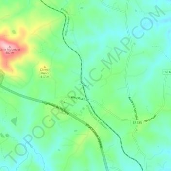
Name: Topografische Karte Wirtz, Höhe, Relief.
Ort: Wirtz, Franklin County, Virginia, United States (37.05653 -79.90948 37.09653 -79.86948)
Durchschnittliche Höhe: 350 m
Minimale Höhe: 295 m
Maximale Höhe: 489 m
Spenden
Rüste dich für dein nächstes Abenteuer:
Als Amazon-Partner verdient diese Seite an qualifizierten Käufen, ohne dass Ihnen zusätzliche Kosten entstehen.
Andere topografische Karten
Klicken Sie auf eine Karte, um ihre Topografie, ihre Höhe und ihr Relief anzuzeigen.
Smith Mountain Lake
United States > Virginia > Franklin County > North Shore
Durchschnittliche Höhe: 275 m
Spenden
Rüste dich für dein nächstes Abenteuer:
Als Amazon-Partner verdient diese Seite an qualifizierten Käufen, ohne dass Ihnen zusätzliche Kosten entstehen.
Boones Mill
United States > Virginia > Franklin County
According to the United States Census Bureau, the town has a total area of 0.73 square miles (1.9 km2), all of it land. The town is in the valley of Maggodee Creek, a southeast-flowing tributary of the Blackwater River, part of the Roanoke River watershed. Murray Knob, elevation 2,286 feet (697 m), rises 2…
Durchschnittliche Höhe: 390 m
Spenden
Rüste dich für dein nächstes Abenteuer:
Als Amazon-Partner verdient diese Seite an qualifizierten Käufen, ohne dass Ihnen zusätzliche Kosten entstehen.