
Topografische Karte Silver Meadows
Interaktive Karte
Klicken Sie auf die Karte, um die Höhe anzuzeigen.
Über diese Karte
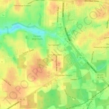
Name: Topografische Karte Silver Meadows, Höhe, Relief.
Durchschnittliche Höhe: 90 m
Minimale Höhe: 64 m
Maximale Höhe: 107 m
Andere topografische Karten
Klicken Sie auf eine Karte, um ihre Topografie, ihre Höhe und ihr Relief anzuzeigen.
Pine Ridge Estates
United States > Alabama > Houston County > Dothan
Pine Ridge Estates, Dothan, Houston County, Alabama, 36305, United States
Durchschnittliche Höhe: 90 m
Rock Creek Park
United States > Alabama > Houston County > Dothan
Rock Creek Park, Dothan, Houston County, Alabama, 36303, United States
Durchschnittliche Höhe: 91 m
Kelly Springs
United States > Alabama > Houston County > Dothan
Kelly Springs, Dothan, Houston County, Alabama, 36303, United States
Durchschnittliche Höhe: 97 m
Dothan
United States > Alabama > Houston County > Dothan
Dothan, Houston County, Alabama, 36303-5834, United States
Durchschnittliche Höhe: 83 m