
Topografische Karte Atlanta
Interaktive Karte
Klicken Sie auf die Karte, um die Höhe anzuzeigen.
Über diese Karte
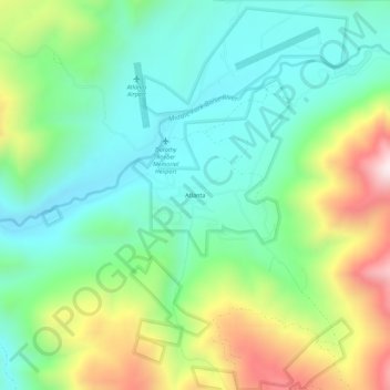
Name: Topografische Karte Atlanta, Höhe, Relief.
Ort: Atlanta, Elmore County, Idaho, 83601, United States (43.78157 -115.14675 43.82157 -115.10675)
Durchschnittliche Höhe: 1’820 m
Minimale Höhe: 1’579 m
Maximale Höhe: 2’331 m
Andere topografische Karten
Klicken Sie auf eine Karte, um ihre Topografie, ihre Höhe und ihr Relief anzuzeigen.
Mountain Home
United States > Idaho > Elmore County
Mountain Home, Elmore County, Idaho, United States
Durchschnittliche Höhe: 967 m
Sugar Bowl
United States > Idaho > Elmore County
Sugar Bowl, Elmore County, Idaho, 83633, United States
Durchschnittliche Höhe: 799 m
Prairie
United States > Idaho > Elmore County
Prairie, Elmore County, Idaho, 83674, United States
Durchschnittliche Höhe: 1’486 m
Pine
United States > Idaho > Elmore County
Pine, Elmore County, Idaho, United States
Durchschnittliche Höhe: 1’462 m
Glenns Ferry
United States > Idaho > Elmore County > Glenns Ferry
Glenns Ferry, Elmore County, Idaho, 83623, United States
Durchschnittliche Höhe: 798 m
Mountain Home
United States > Idaho > Elmore County > Mountain Home
Mountain Home, Elmore County, Idaho, 83647, United States
Durchschnittliche Höhe: 973 m