
Topografische Karte Lowden
Interaktive Karte
Klicken Sie auf die Karte, um die Höhe anzuzeigen.
Über diese Karte
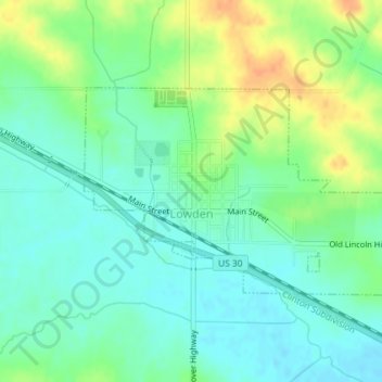
Name: Topografische Karte Lowden, Höhe, Relief.
Ort: Lowden, Cedar County, Iowa, United States (41.85167 -90.93719 41.86637 -90.90766)
Durchschnittliche Höhe: 227 m
Minimale Höhe: 214 m
Maximale Höhe: 249 m
Andere topografische Karten
Klicken Sie auf eine Karte, um ihre Topografie, ihre Höhe und ihr Relief anzuzeigen.
Cedar Valley
United States > Iowa > Cedar County
Cedar Valley, Cedar County, Iowa, United States
Durchschnittliche Höhe: 229 m
Rock Creek
United States > Iowa > Cedar County
Rock Creek, Cedar County, Iowa, 52772, United States
Durchschnittliche Höhe: 235 m
Clarence
United States > Iowa > Cedar County > Clarence
Clarence, Cedar County, Iowa, 52216, United States
Durchschnittliche Höhe: 252 m
West Branch
United States > Iowa > Cedar County
West Branch, Cedar County, Iowa, 52538, United States
Durchschnittliche Höhe: 228 m
Stanwood
United States > Iowa > Cedar County
Stanwood, Cedar County, Iowa, United States
Durchschnittliche Höhe: 255 m
Clarence
United States > Iowa > Cedar County
Clarence, Cedar County, Iowa, United States
Durchschnittliche Höhe: 253 m