
Topografische Karte Fort Washakie
Interaktive Karte
Klicken Sie auf die Karte, um die Höhe anzuzeigen.
Über diese Karte
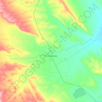
Name: Topografische Karte Fort Washakie, Höhe, Relief.
Durchschnittliche Höhe: 1’742 m
Minimale Höhe: 1’635 m
Maximale Höhe: 1’942 m
Andere topografische Karten
Klicken Sie auf eine Karte, um ihre Topografie, ihre Höhe und ihr Relief anzuzeigen.
Sweetwater Station
United States > Wyoming > Fremont County
Sweetwater Station, Fremont County, Wyoming, United States
Durchschnittliche Höhe: 2’021 m
Dubois
United States > Wyoming > Fremont County
Dubois, Fremont County, Wyoming, 82513, United States
Durchschnittliche Höhe: 2’167 m
Arapahoe
United States > Wyoming > Fremont County
Arapahoe, Fremont County, Wyoming, United States
Durchschnittliche Höhe: 1’555 m
Pavillion
United States > Wyoming > Fremont County
Pavillion, Fremont County, Wyoming, 82523, United States
Durchschnittliche Höhe: 1’665 m
Whiskey Mountain
United States > Wyoming > Fremont County
Whiskey Mountain, Fremont County, Wyoming, United States
Durchschnittliche Höhe: 3’177 m
Mount Popo Agie
United States > Wyoming > Fremont County
Mount Popo Agie, Fremont County, Wyoming, United States
Durchschnittliche Höhe: 2’848 m
Boysen State Park
United States > Wyoming > Fremont County > Shoshoni
Boysen State Park, Shoshoni, Fremont County, Wyoming, United States
Durchschnittliche Höhe: 1’553 m
Dinwoody Lake
United States > Wyoming > Fremont County
Dinwoody Lake, Fremont County, Wyoming, United States
Durchschnittliche Höhe: 2’074 m
Riverton
United States > Wyoming > Fremont County
Riverton, Fremont County, Wyoming, 82501, United States
Durchschnittliche Höhe: 1’529 m
Fremont Peak
United States > Wyoming > Fremont County
Fremont Peak, Fremont County, Wyoming, United States
Durchschnittliche Höhe: 3’703 m
Cirque of the Towers
United States > Wyoming > Fremont County
Cirque of the Towers, Fremont County, Wyoming, United States
Durchschnittliche Höhe: 3’347 m