
Topografische Karte Town of Jacksonport
Interaktive Karte
Klicken Sie auf die Karte, um die Höhe anzuzeigen.
Über diese Karte
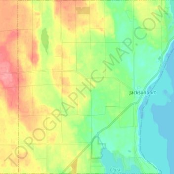
Name: Topografische Karte Town of Jacksonport, Höhe, Relief.
Ort: Town of Jacksonport, Door County, Wisconsin, United States (44.93687 -87.27565 45.02549 -87.15154)
Durchschnittliche Höhe: 205 m
Minimale Höhe: 172 m
Maximale Höhe: 255 m
Andere topografische Karten
Klicken Sie auf eine Karte, um ihre Topografie, ihre Höhe und ihr Relief anzuzeigen.
Little Sturgeon
United States > Wisconsin > Door County
Little Sturgeon, Town of Gardner, Door County, Wisconsin, United States
Durchschnittliche Höhe: 179 m
Brussels
United States > Wisconsin > Door County
Brussels, Town of Brussels, Door County, Wisconsin, 54204, United States
Durchschnittliche Höhe: 227 m
Town of Egg Harbor
United States > Wisconsin > Door County
Town of Egg Harbor, Door County, Wisconsin, 54209, United States
Durchschnittliche Höhe: 196 m
Fish Creek
United States > Wisconsin > Door County > Fish Creek
Fish Creek, Town of Gibraltar, Door County, Wisconsin, 54212, United States
Durchschnittliche Höhe: 189 m
Ellison Bay
United States > Wisconsin > Door County
Ellison Bay, Town of Liberty Grove, Door County, Wisconsin, 54210, United States
Durchschnittliche Höhe: 194 m
Sturgeon Bay
United States > Wisconsin > Door County
Sturgeon Bay, Door County, Wisconsin, 54235, United States
Durchschnittliche Höhe: 199 m
Egg Harbor
United States > Wisconsin > Door County
Egg Harbor, Door County, Wisconsin, United States
Durchschnittliche Höhe: 194 m