Geolokalisieren

Topografische Karte CN

Interaktive Karte

Klicken Sie auf die Karte, um die Höhe anzuzeigen.

Über diese Karte

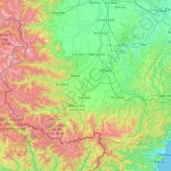
Name: Topografische Karte CN, Höhe, Relief.

Ort: CN, PIE, Itália (44.05972 6.85451 44.85661 8.26921)

Durchschnittliche Höhe: 1’021 m

Minimale Höhe: 0 m

Maximale Höhe: 3’790 m

Andere topografische Karten

Klicken Sie auf eine Karte, um ihre Topografie, ihre Höhe und ihr Relief anzuzeigen.

Venasca

Itália > PIE > Venasca

Venasca, CN, PIE, Itália

Durchschnittliche Höhe: 793 m

Porte

Itália > PIE > Porte

Porte, TO, PIE, Itália

Durchschnittliche Höhe: 686 m

Rive

Itália > PIE > Rive

Rive, VC, PIE, Itália

Durchschnittliche Höhe: 122 m

Elva

Itália > PIE > Elva

Elva, CN, PIE, Itália

Durchschnittliche Höhe: 1’803 m

Novalesa

Itália > PIE > Novalesa

Novalesa, TO, PIE, Itália

Durchschnittliche Höhe: 1’751 m

Luserna San Giovanni

Itália > PIE > Luserna San Giovanni

Luserna San Giovanni, TO, PIE, 10062, Itália

Durchschnittliche Höhe: 655 m

Caltignaga

Itália > PIE > Caltignaga

Caltignaga, NO, PIE, 28021, Itália

Durchschnittliche Höhe: 183 m

Verbania

Itália > PIE > Verbania

Verbania, VB, PIE, Itália

Durchschnittliche Höhe: 399 m

Intragna

Itália > PIE > Intragna

Intragna, VB, PIE, Itália

Durchschnittliche Höhe: 924 m

Il Forte

Itália > PIE > Oulx

Il Forte, Oulx, TO, PIE, Itália

Durchschnittliche Höhe: 1’356 m

Novara

Itália > PIE > Novara

Novara, NO, PIE, 28100, Itália

Durchschnittliche Höhe: 149 m

Asti

Itália > PIE > Asti

Asti, AT, PIE, 14100, Itália

Durchschnittliche Höhe: 173 m

Gaido

Itália > PIE > Gaido

Gaido, TO, PIE, Itália

Durchschnittliche Höhe: 1’546 m

Bruno

Itália > PIE > Bruno

Bruno, AT, PIE, Itália

Durchschnittliche Höhe: 172 m