
Spenden
Rüste dich für dein nächstes Abenteuer:
Als Amazon-Partner verdient diese Seite an qualifizierten Käufen, ohne dass Ihnen zusätzliche Kosten entstehen.
Topografische Karte LaSalle
Klicken Sie auf die Karte, um die Höhe anzuzeigen.
Spenden
Rüste dich für dein nächstes Abenteuer:
Als Amazon-Partner verdient diese Seite an qualifizierten Käufen, ohne dass Ihnen zusätzliche Kosten entstehen.
Über diese Karte
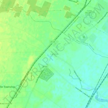
Name: Topografische Karte LaSalle, Höhe, Relief.
Ort: LaSalle, Monroe County, Michigan, 48145, United States (41.84782 -83.47216 41.88782 -83.43216)
Durchschnittliche Höhe: 183 m
Minimale Höhe: 175 m
Maximale Höhe: 190 m
Spenden
Rüste dich für dein nächstes Abenteuer:
Als Amazon-Partner verdient diese Seite an qualifizierten Käufen, ohne dass Ihnen zusätzliche Kosten entstehen.
Andere topografische Karten
Klicken Sie auf eine Karte, um ihre Topografie, ihre Höhe und ihr Relief anzuzeigen.
Monroe
United States > Michigan > Monroe County
According to the United States Census Bureau, the city has a total area of 10.18 square miles (26.37 km2), of which 9.17 square miles (23.75 km2) is land and 1.01 square miles (2.62 km2) (9.92%) is water. Monroe sits at the lowest elevation in state of Michigan, which is the shores of Lake Erie at 571 feet…
Durchschnittliche Höhe: 182 m
Frenchtown Charter Township
United States > Michigan > Monroe County
The township is in eastern Monroe County and is bordered to the southeast by Lake Erie. Many of the township's communities are located near the lake. Sterling State Park is located along the southern edge of the township and is the only Michigan state park on Lake Erie. Small pieces of the township are…
Durchschnittliche Höhe: 181 m
Spenden
Rüste dich für dein nächstes Abenteuer:
Als Amazon-Partner verdient diese Seite an qualifizierten Käufen, ohne dass Ihnen zusätzliche Kosten entstehen.
Spenden
Rüste dich für dein nächstes Abenteuer:
Als Amazon-Partner verdient diese Seite an qualifizierten Käufen, ohne dass Ihnen zusätzliche Kosten entstehen.
Monroe
United States > Michigan > Monroe County
Monroe is in eastern Monroe County, with its city limits extending southeast3 miles (5 km) from the downtown to Lake Erie. The average elevation of the city is 594 feet (181 metres), decreasing to 571 feet (174 metres) at Lake Erie, which sits at the lowest elevation in Michigan. The Port of Monroe is the only…
Durchschnittliche Höhe: 182 m
River Raisin
United States > Michigan > Monroe County > Raisinville Township > Grape
Durchschnittliche Höhe: 192 m
Spenden
Rüste dich für dein nächstes Abenteuer:
Als Amazon-Partner verdient diese Seite an qualifizierten Käufen, ohne dass Ihnen zusätzliche Kosten entstehen.
Frenchtown Charter Township
United States > Michigan > Monroe County
The township is in eastern Monroe County and is bordered to the southeast by Lake Erie. Many of the township's communities are located near the lake. Sterling State Park is located along the southern edge of the township and is the only Michigan state park on Lake Erie. Small pieces of the township are…
Durchschnittliche Höhe: 181 m
Spenden
Rüste dich für dein nächstes Abenteuer:
Als Amazon-Partner verdient diese Seite an qualifizierten Käufen, ohne dass Ihnen zusätzliche Kosten entstehen.