
Spenden
Rüste dich für dein nächstes Abenteuer:
Als Amazon-Partner verdient diese Seite an qualifizierten Käufen, ohne dass Ihnen zusätzliche Kosten entstehen.
Topografische Karte American River
Klicken Sie auf die Karte, um die Höhe anzuzeigen.
Spenden
Rüste dich für dein nächstes Abenteuer:
Als Amazon-Partner verdient diese Seite an qualifizierten Käufen, ohne dass Ihnen zusätzliche Kosten entstehen.
American River
The North Fork is the longest tributary of the American River, at 88 miles (142 km). It begins at an elevation of about 7,900 feet (2,400 m) near Lake Tahoe in Placer County at Mountain Meadow Lake, just northeast of Granite Chief and immediately due west of Palisades Tahoe (formerly Squaw Valley) Ski Resort. It flows westward through remote wilderness areas.
Spenden
Rüste dich für dein nächstes Abenteuer:
Als Amazon-Partner verdient diese Seite an qualifizierten Käufen, ohne dass Ihnen zusätzliche Kosten entstehen.
Über diese Karte
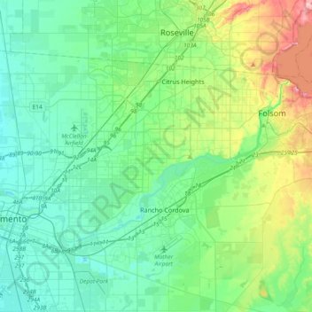
Name: Topografische Karte American River, Höhe, Relief.
Durchschnittliche Höhe: 44 m
Minimale Höhe: 0 m
Maximale Höhe: 197 m
Spenden
Rüste dich für dein nächstes Abenteuer:
Als Amazon-Partner verdient diese Seite an qualifizierten Käufen, ohne dass Ihnen zusätzliche Kosten entstehen.