
Topografische Karte Ward Butte
Interaktive Karte
Klicken Sie auf die Karte, um die Höhe anzuzeigen.
Über diese Karte
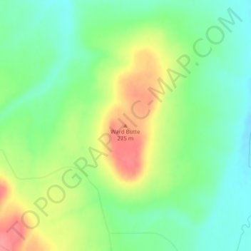
Name: Topografische Karte Ward Butte, Höhe, Relief.
Ort: Ward Butte, Umatilla County, Oregon, 97826, United States (45.73092 -119.38812 45.73102 -119.38802)
Durchschnittliche Höhe: 239 m
Minimale Höhe: 207 m
Maximale Höhe: 288 m
Andere topografische Karten
Klicken Sie auf eine Karte, um ihre Topografie, ihre Höhe und ihr Relief anzuzeigen.
Pendleton
United States > Oregon > Umatilla County
Pendleton, Umatilla County, Oregon, 97801, United States
Durchschnittliche Höhe: 402 m
Mission
United States > Oregon > Umatilla County
Mission, Umatilla County, Oregon, United States
Durchschnittliche Höhe: 429 m
McNary Lock and Dam
United States > Oregon > Umatilla County > McNary
McNary Lock and Dam, McNary, Umatilla County, Oregon, United States
Durchschnittliche Höhe: 106 m
Wallula Gap
United States > Oregon > Umatilla County
Wallula Gap, Umatilla County, Oregon, 99363, United States
Durchschnittliche Höhe: 313 m
Echo
United States > Oregon > Umatilla County
Echo, Umatilla County, Oregon, United States
Durchschnittliche Höhe: 212 m
Adams
United States > Oregon > Umatilla County
Adams, Umatilla County, Oregon, United States
Durchschnittliche Höhe: 475 m
Tollgate
United States > Oregon > Umatilla County > Tollgate
Tollgate, Umatilla County, Oregon, United States
Durchschnittliche Höhe: 1’511 m
Carney Butte
United States > Oregon > Umatilla County
Carney Butte, Umatilla County, Oregon, United States
Durchschnittliche Höhe: 1’339 m
Stanfield
United States > Oregon > Umatilla County
Stanfield, Umatilla County, Oregon, United States
Durchschnittliche Höhe: 193 m
Meacham
United States > Oregon > Umatilla County > Meacham
Meacham, Umatilla County, Oregon, 97859, United States
Durchschnittliche Höhe: 1’166 m
Hermiston
United States > Oregon > Umatilla County
Hermiston, Umatilla County, Oregon, 97838, United States
Durchschnittliche Höhe: 160 m
Umatilla
United States > Oregon > Umatilla County > Umatilla
Umatilla, Umatilla County, Oregon, United States
Durchschnittliche Höhe: 141 m