
Topografische Karte Palestine
Interaktive Karte
Klicken Sie auf die Karte, um die Höhe anzuzeigen.
Über diese Karte
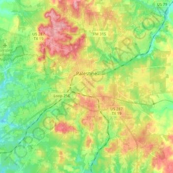
Name: Topografische Karte Palestine, Höhe, Relief.
Ort: Palestine, Anderson County, Texas, United States (31.69527 -95.72426 31.80843 -95.56776)
Durchschnittliche Höhe: 136 m
Minimale Höhe: 85 m
Maximale Höhe: 204 m
About 40% of the content from the 2003 Space Shuttle Columbia disaster was recovered. seven astronauts were killed in the accident.[19] Debris from Columbia was found in and outside Palestine and other East Texas towns.[20][21] Palestine's NASA Columbia Scientific Balloon Facility (renamed in honor of the shuttle crew), has flown 1,700 high-altitude balloons for universities and research agencies.
Andere topografische Karten
Klicken Sie auf eine Karte, um ihre Topografie, ihre Höhe und ihr Relief anzuzeigen.
Daly Mountain
United States > Texas > Anderson County > Neches
Daly Mountain, Neches, Anderson County, Texas, 75779, United States
Durchschnittliche Höhe: 128 m
Fosterville
United States > Texas > Anderson County
Fosterville, Anderson County, Texas, United States
Durchschnittliche Höhe: 133 m
Yard
United States > Texas > Anderson County
Yard, Anderson County, Texas, United States
Durchschnittliche Höhe: 78 m