
Topografische Karte Rochehaut
Interaktive Karte
Klicken Sie auf die Karte, um die Höhe anzuzeigen.
Über diese Karte
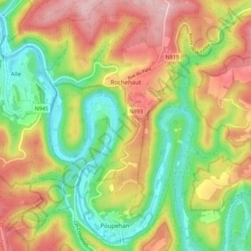
Name: Topografische Karte Rochehaut, Höhe, Relief.
Ort: Rochehaut, Bouillon, Neufchâteau, Luxemburg, Wallonië, België (49.80637 4.97086 49.85692 5.02732)
Durchschnittliche Höhe: 298 m
Minimale Höhe: 182 m
Maximale Höhe: 431 m
Andere topografische Karten
Klicken Sie auf eine Karte, um ihre Topografie, ihre Höhe und ihr Relief anzuzeigen.
Corbion
België > Luxemburg > Neufchâteau > Bouillon
Corbion, Bouillon, Neufchâteau, Luxemburg, Wallonië, 6838, België
Durchschnittliche Höhe: 344 m
Noirefontaine
België > Luxemburg > Neufchâteau > Bouillon > Noirefontaine
Noirefontaine, Bouillon, Neufchâteau, Luxemburg, Wallonië, 6831, België
Durchschnittliche Höhe: 331 m
Dohan
België > Luxemburg > Neufchâteau > Bouillon
Dohan, Bouillon, Neufchâteau, Luxemburg, Wallonië, België
Durchschnittliche Höhe: 284 m
Poupehan
België > Luxemburg > Neufchâteau > Bouillon
Poupehan, Bouillon, Neufchâteau, Luxemburg, Wallonië, België
Durchschnittliche Höhe: 270 m