
Spenden
Rüste dich für dein nächstes Abenteuer:
Als Amazon-Partner verdient diese Seite an qualifizierten Käufen, ohne dass Ihnen zusätzliche Kosten entstehen.
Topografische Karte Banner Elk
Klicken Sie auf die Karte, um die Höhe anzuzeigen.
Spenden
Rüste dich für dein nächstes Abenteuer:
Als Amazon-Partner verdient diese Seite an qualifizierten Käufen, ohne dass Ihnen zusätzliche Kosten entstehen.
Banner Elk
Banner Elk is located in North America's humid continental climate zone due to its elevation, which gives it a climate more like that of Altoona, Pennsylvania, than Asheville, North Carolina, during the winter. During the summer the temperatures are much like a mountain lake town in New Hampshire. The town typically has cold, snowy winters and mild summers.
Spenden
Rüste dich für dein nächstes Abenteuer:
Als Amazon-Partner verdient diese Seite an qualifizierten Käufen, ohne dass Ihnen zusätzliche Kosten entstehen.
Über diese Karte
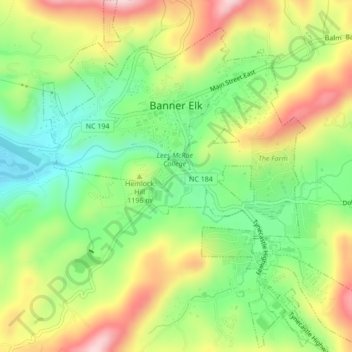
Name: Topografische Karte Banner Elk, Höhe, Relief.
Ort: Banner Elk, Avery County, North Carolina, United States (36.13897 -81.88774 36.17356 -81.84810)
Durchschnittliche Höhe: 1’164 m
Minimale Höhe: 1’036 m
Maximale Höhe: 1’332 m
Spenden
Rüste dich für dein nächstes Abenteuer:
Als Amazon-Partner verdient diese Seite an qualifizierten Käufen, ohne dass Ihnen zusätzliche Kosten entstehen.
Andere topografische Karten
Klicken Sie auf eine Karte, um ihre Topografie, ihre Höhe und ihr Relief anzuzeigen.
Spenden
Rüste dich für dein nächstes Abenteuer:
Als Amazon-Partner verdient diese Seite an qualifizierten Käufen, ohne dass Ihnen zusätzliche Kosten entstehen.
Linville River
United States > North Carolina > Avery County > Linville
Durchschnittliche Höhe: 1’188 m
Spenden
Rüste dich für dein nächstes Abenteuer:
Als Amazon-Partner verdient diese Seite an qualifizierten Käufen, ohne dass Ihnen zusätzliche Kosten entstehen.
Beech Mountain
United States > North Carolina > Avery County > Beech Mountain
Beech Mountain is a mountain in the North Carolina High Country and wholly in the Pisgah National Forest. Its elevation reaches 5,506 feet (1,657 m) and generates feeder streams for the Elk River. Nestled on the top is the Town of Beech Mountain.
Durchschnittliche Höhe: 1’433 m
Sugar Mountain
United States > North Carolina > Avery County > Sugar Mountain
Sugar Mountain is a mountain in the North Carolina High Country and wholly in the Pisgah National Forest. Its elevation reaches 5,236 feet (1,596 m) and is split along the Eastern Continental Divide, generating feeder streams for the Linville, Elk, and North Toe rivers. On its north slope resides the Village…
Durchschnittliche Höhe: 1’385 m
Spenden
Rüste dich für dein nächstes Abenteuer:
Als Amazon-Partner verdient diese Seite an qualifizierten Käufen, ohne dass Ihnen zusätzliche Kosten entstehen.