
Topografische Karte Zell (Mosel)
Interaktive Karte
Klicken Sie auf die Karte, um die Höhe anzuzeigen.
Über diese Karte
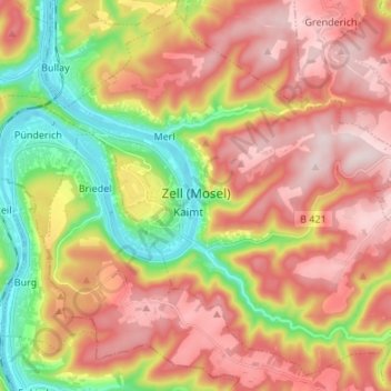
Name: Topografische Karte Zell (Mosel), Höhe, Relief.
Durchschnittliche Höhe: 287 m
Minimale Höhe: 89 m
Maximale Höhe: 458 m
Zell is an hour's drive from both Koblenz and Trier, more or less halfway between these two cities. The nearest town going towards Koblenz is Cochem, and the nearest two going towards Trier are Traben-Trarbach and Bernkastel-Kues. To both Frankfurt-Hahn Airport on the Hunsrück and the spa town of Bad Bertrich in the Voreifel it is half an hour's drive. The parts of town lying on the river, the Old Town, Kaimt and Merl, are at an elevation of roughly 100 m above sea level on a remarkable bow in the river Moselle, known as the Zeller Hamm.
Andere topografische Karten
Klicken Sie auf eine Karte, um ihre Topografie, ihre Höhe und ihr Relief anzuzeigen.
Bullay
Germany > Rhineland-Palatinate > Landkreis Cochem-Zell
Bullay, Zell (Mosel), Landkreis Cochem-Zell, Rhineland-Palatinate, Germany
Durchschnittliche Höhe: 207 m
Ulmen
Germany > Rhineland-Palatinate > Landkreis Cochem-Zell
Ulmen, Landkreis Cochem-Zell, Rhineland-Palatinate, 56766, Germany
Durchschnittliche Höhe: 455 m
Moselhöhe Ediger-Eller
Germany > Rhineland-Palatinate > Landkreis Cochem-Zell > Ediger-Eller
Moselhöhe Ediger-Eller, Ediger-Eller, Cochem, Landkreis Cochem-Zell, Rhineland-Palatinate, 56814, Germany
Durchschnittliche Höhe: 285 m
Cochem
Germany > Rhineland-Palatinate > Landkreis Cochem-Zell
Cochem, Landkreis Cochem-Zell, Rhineland-Palatinate, Germany
Durchschnittliche Höhe: 286 m
Beilstein
Germany > Rhineland-Palatinate > Landkreis Cochem-Zell
Beilstein, Cochem, Landkreis Cochem-Zell, Rhineland-Palatinate, Germany
Durchschnittliche Höhe: 234 m
Bremm
Germany > Rhineland-Palatinate > Landkreis Cochem-Zell
Bremm, Cochem, Landkreis Cochem-Zell, Rhineland-Palatinate, Germany
Durchschnittliche Höhe: 258 m
Neef
Germany > Rhineland-Palatinate > Landkreis Cochem-Zell > Neef
Neef, Zell (Mosel), Landkreis Cochem-Zell, Rhineland-Palatinate, Germany
Durchschnittliche Höhe: 213 m