
Topografische Karte Aksaray
Interaktive Karte
Klicken Sie auf die Karte, um die Höhe anzuzeigen.
Über diese Karte
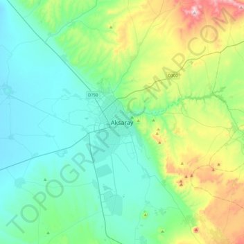
Name: Topografische Karte Aksaray, Höhe, Relief.
Durchschnittliche Höhe: 1’077 m
Minimale Höhe: 927 m
Maximale Höhe: 1’601 m
Aksaray (pronounced ) is a city in the Central Anatolia region of Turkey and the capital district of Aksaray Province. According to 2009 census figures, the population of the province is 376 907 of which 171,423 live in the city of Aksaray. The district covers an area of 4,589 km2 (1,772 sq mi), and the average elevation is 980 m (3,215 ft), with the highest point being Mt. Hasan at 3,253 m (10,673 ft).