
Topografische Karte Alcañiz
Klicken Sie auf die Karte, um die Höhe anzuzeigen.
Alcañiz
El relieve del municipio es el característico de la amplia comarca a la que pertenece, que forma un paisaje rocoso con ondulaciones, recorrido por el río Guadalope. Las elevaciones más destacadas son Puig Moreno (465 m) al noroeste, sierra de Vizcuerno (496 m) al norte, Chinchol (440 m) al este y Peña Blanca (466 m) al oeste. Destacan también las lagunas Las Saladas, el pinar La Mangranera y el estanque de la Estanca. La altitud oscila entre los 496 m en la Sierra de Vizcuerno (El Campanero) y los 240 m a orillas del río Guadalope, en el embalse de Caspe II. La ciudad se alza a 340 m sobre el nivel del mar.
Über diese Karte
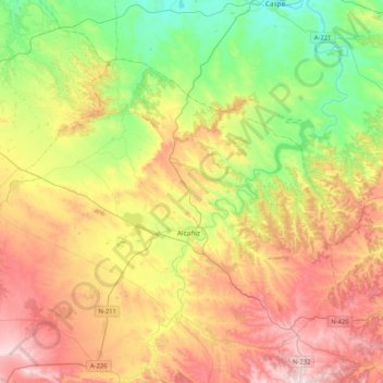
Name: Topografische Karte Alcañiz, Höhe, Relief.
Ort: Alcañiz, Bajo Aragón, Teruel, Aragón, España (40.97551 -0.37625 41.19201 0.03692)
Durchschnittliche Höhe: 364 m
Minimale Höhe: 108 m
Maximale Höhe: 696 m
Andere topografische Karten
Klicken Sie auf eine Karte, um ihre Topografie, ihre Höhe und ihr Relief anzuzeigen.
Salada de la Jabonera de las Torrazas
España > Aragón > Bajo Aragón > Alcañiz
Durchschnittliche Höhe: 354 m