
Spenden
Rüste dich für dein nächstes Abenteuer:
Als Amazon-Partner verdient diese Seite an qualifizierten Käufen, ohne dass Ihnen zusätzliche Kosten entstehen.
Topografische Karte Grand Coulee Dam
Klicken Sie auf die Karte, um die Höhe anzuzeigen.
Spenden
Rüste dich für dein nächstes Abenteuer:
Als Amazon-Partner verdient diese Seite an qualifizierten Käufen, ohne dass Ihnen zusätzliche Kosten entstehen.
Grand Coulee Dam
After power shortages in the Northwest during the 1960s, it was determined the six remaining planned pumps be pump-generators. When energy demand is high, the pump-generators can generate electricity with water from the Banks Lake feeder canal adjacent to the dam at a higher elevation. By 1973, the Pump-Generating Plant was completed and the first two generators (P/G-7 and P/G-8) were operational. In 1983, two more generators went online, and by January 1984 the final two were operational. The six pump-generators added 314 MW to the dam's capacity. In May 2009, the Pump-Generating Plant was officially renamed the John W. Keys III Pump-Generating Power Plant after John W. Keys III, the U.S. Bureau of Reclamation's commissioner from 2001 to 2006.
Spenden
Rüste dich für dein nächstes Abenteuer:
Als Amazon-Partner verdient diese Seite an qualifizierten Käufen, ohne dass Ihnen zusätzliche Kosten entstehen.
Über diese Karte
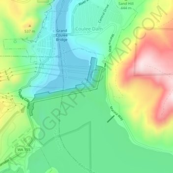
Name: Topografische Karte Grand Coulee Dam, Höhe, Relief.
Durchschnittliche Höhe: 423 m
Minimale Höhe: 291 m
Maximale Höhe: 676 m
Spenden
Rüste dich für dein nächstes Abenteuer:
Als Amazon-Partner verdient diese Seite an qualifizierten Käufen, ohne dass Ihnen zusätzliche Kosten entstehen.
Andere topografische Karten
Klicken Sie auf eine Karte, um ihre Topografie, ihre Höhe und ihr Relief anzuzeigen.
Spenden
Rüste dich für dein nächstes Abenteuer:
Als Amazon-Partner verdient diese Seite an qualifizierten Käufen, ohne dass Ihnen zusätzliche Kosten entstehen.
Spenden
Rüste dich für dein nächstes Abenteuer:
Als Amazon-Partner verdient diese Seite an qualifizierten Käufen, ohne dass Ihnen zusätzliche Kosten entstehen.
Spenden
Rüste dich für dein nächstes Abenteuer:
Als Amazon-Partner verdient diese Seite an qualifizierten Käufen, ohne dass Ihnen zusätzliche Kosten entstehen.
Spenden
Rüste dich für dein nächstes Abenteuer:
Als Amazon-Partner verdient diese Seite an qualifizierten Käufen, ohne dass Ihnen zusätzliche Kosten entstehen.