
Topografische Karte Quandary Peak
Interaktive Karte
Klicken Sie auf die Karte, um die Höhe anzuzeigen.
Über diese Karte
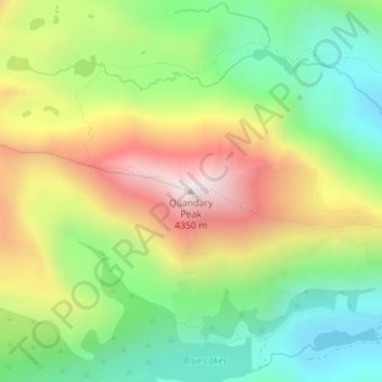
Name: Topografische Karte Quandary Peak, Höhe, Relief.
Ort: Quandary Peak, Summit County, Colorado, United States (39.39724 -106.10648 39.39734 -106.10638)
Durchschnittliche Höhe: 3’833 m
Minimale Höhe: 3’466 m
Maximale Höhe: 4’343 m
Quandary Peak is the highest summit of the Tenmile Range in the Rocky Mountains of North America and is the most commonly climbed fourteener in Colorado. It has nearly the same elevation as Castle Peak and Mount Evans. It lies in Summit County and within the White River National Forest about 6 miles (10 km) south-southwest of the town of Breckenridge.
Andere topografische Karten
Klicken Sie auf eine Karte, um ihre Topografie, ihre Höhe und ihr Relief anzuzeigen.
Silverthorne
United States > Colorado > Summit County
Silverthorne, Summit County, Colorado, 80497, United States
Durchschnittliche Höhe: 2’883 m
Breckenridge
United States > Colorado > Summit County
Breckenridge, Summit County, Colorado, 80424, United States
Durchschnittliche Höhe: 3’072 m
Frisco
United States > Colorado > Summit County
Frisco, Summit County, Colorado, United States
Durchschnittliche Höhe: 2’835 m
Copper Mountain
United States > Colorado > Summit County
Copper Mountain, Summit County, Colorado, United States
Durchschnittliche Höhe: 3’483 m
Silverthorne
United States > Colorado > Summit County
Silverthorne, Summit County, Colorado, 80497, United States
Durchschnittliche Höhe: 2’858 m
Dillon
United States > Colorado > Summit County
Dillon, Summit County, Colorado, United States
Durchschnittliche Höhe: 2’796 m
Boreas Pass
United States > Colorado > Summit County
Boreas Pass, Summit County, Colorado, United States
Durchschnittliche Höhe: 3’559 m
Blue River
United States > Colorado > Summit County
Blue River, Summit County, Colorado, United States
Durchschnittliche Höhe: 3’075 m
Keystone
United States > Colorado > Summit County
Keystone, Summit County, Colorado, 80435, United States
Durchschnittliche Höhe: 3’300 m
Bald Mountain
United States > Colorado > Summit County
Bald Mountain, Summit County, Colorado, United States
Durchschnittliche Höhe: 3’737 m