
Topografische Karte Bryce Canyon National Park
Interaktive Karte
Klicken Sie auf die Karte, um die Höhe anzuzeigen.
Über diese Karte
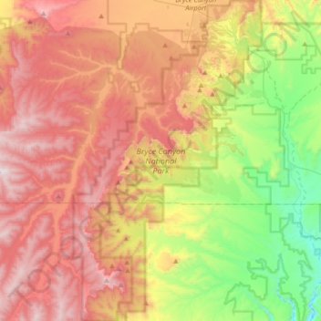
Name: Topografische Karte Bryce Canyon National Park, Höhe, Relief.
Durchschnittliche Höhe: 2’259 m
Minimale Höhe: 1’640 m
Maximale Höhe: 2’902 m
Bryce Canyon National Park (/braɪs/) is an American national park located in southwestern Utah. The major feature of the park is Bryce Canyon, which despite its name, is not a canyon, but a collection of giant natural amphitheaters along the eastern side of the Paunsaugunt Plateau. Bryce is distinctive due to geological structures called hoodoos, formed by frost weathering and stream erosion of the river and lake bed sedimentary rocks. The red, orange, and white colors of the rocks provide spectacular views for park visitors. Bryce Canyon National Park is much smaller and sits at a much higher elevation than nearby Zion National Park. The rim at Bryce varies from 8,000 to 9,000 feet (2,400 to 2,700 m).
Andere topografische Karten
Klicken Sie auf eine Karte, um ihre Topografie, ihre Höhe und ihr Relief anzuzeigen.
Boulder
United States > Utah > Garfield County
Boulder, Garfield County, Utah, 84716, United States
Durchschnittliche Höhe: 2’115 m
Panguitch
United States > Utah > Garfield County
Panguitch, Garfield County, Utah, 84759, United States
Durchschnittliche Höhe: 2’043 m
Mount Ogden
United States > Utah > Garfield County
Mount Ogden, Garfield County, Utah, United States
Durchschnittliche Höhe: 2’226 m
Escalante
United States > Utah > Garfield County
Escalante, Garfield County, Utah, 84726, United States
Durchschnittliche Höhe: 1’781 m
Henry Mountains
United States > Utah > Garfield County
Henry Mountains, Garfield County, Utah, United States
Durchschnittliche Höhe: 1’936 m
Bryce Canyon
United States > Utah > Garfield County > Tropic
Bryce Canyon, Tropic, Garfield County, Utah, United States
Durchschnittliche Höhe: 2’247 m