
Spenden
Rüste dich für dein nächstes Abenteuer:
Als Amazon-Partner verdient diese Seite an qualifizierten Käufen, ohne dass Ihnen zusätzliche Kosten entstehen.
Topografische Karte Sunriver
Klicken Sie auf die Karte, um die Höhe anzuzeigen.
Spenden
Rüste dich für dein nächstes Abenteuer:
Als Amazon-Partner verdient diese Seite an qualifizierten Käufen, ohne dass Ihnen zusätzliche Kosten entstehen.
Über diese Karte
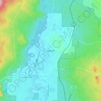
Name: Topografische Karte Sunriver, Höhe, Relief.
Ort: Sunriver, Deschutes County, Oregon, 97707, United States (43.84400 -121.47852 43.92400 -121.39852)
Durchschnittliche Höhe: 1’312 m
Minimale Höhe: 1’261 m
Maximale Höhe: 1’504 m
Spenden
Rüste dich für dein nächstes Abenteuer:
Als Amazon-Partner verdient diese Seite an qualifizierten Käufen, ohne dass Ihnen zusätzliche Kosten entstehen.
Andere topografische Karten
Klicken Sie auf eine Karte, um ihre Topografie, ihre Höhe und ihr Relief anzuzeigen.
Bend
United States > Oregon > Deschutes County
Bend is characterized by its distinctive topography, situated at an elevation of approximately 3,623 feet (1,105 meters) above sea level. The city lies within the high desert region of Central Oregon, bordered by the Cascade Mountains to the west, which provide a dramatic backdrop with peaks like the Three…
Durchschnittliche Höhe: 1’121 m
Redmond
United States > Oregon > Deschutes County
The city encompasses 15.5 square miles (40 km2) and is on a plateau, at an elevation of 3,077 feet (938 m). Redmond is 15 miles (24 km) north of Bend—the county seat of Deschutes County—144 miles (232 km) from Portland, 129 miles (208 km) from Salem—the capital of Oregon—and 126 miles (203 km) from Eugene.
Durchschnittliche Höhe: 923 m
Spenden
Rüste dich für dein nächstes Abenteuer:
Als Amazon-Partner verdient diese Seite an qualifizierten Käufen, ohne dass Ihnen zusätzliche Kosten entstehen.
Bend
United States > Oregon > Deschutes County
The Deschutes River runs through Bend, where it is dammed to form Mirror Pond. Bend's elevation is 3,623 feet (1,104 metres) above sea level. The city has a total area of 33.27 square miles (86.17 square kilometres), of which 33.01 sq mi (85.50 km2) is land and 0.26 sq mi (0.67 km2) is water.
Durchschnittliche Höhe: 1’121 m
Bend
United States > Oregon > Deschutes County
The Deschutes River runs through Bend, where it is dammed to form Mirror Pond. Bend's elevation is 3,623 feet (1,104 metres) above sea level.
Durchschnittliche Höhe: 1’121 m
Bend
United States > Oregon > Deschutes County
The Deschutes River runs through Bend, where it is dammed to form Mirror Pond. Bend's elevation is 3,623 feet (1,104 metres) above sea level.
Durchschnittliche Höhe: 1’121 m
Spenden
Rüste dich für dein nächstes Abenteuer:
Als Amazon-Partner verdient diese Seite an qualifizierten Käufen, ohne dass Ihnen zusätzliche Kosten entstehen.
Bend
United States > Oregon > Deschutes County
The Deschutes River runs through Bend, where it is dammed to form Mirror Pond. Bend's elevation is 3,623 feet (1,104 metres) above sea level.
Durchschnittliche Höhe: 1’121 m
Redmond
United States > Oregon > Deschutes County > Redmond
The city encompasses 15.5 square miles (40 km2) and is on a plateau, at an elevation of 3,077 feet (938 m). Redmond is 15 miles (24 km) north of Bend—the county seat of Deschutes County—144 miles (232 km) from Portland, 129 miles (208 km) from Salem—the capital of Oregon—and 126 miles (203 km) from Eugene.
Durchschnittliche Höhe: 921 m