
Spenden
Rüste dich für dein nächstes Abenteuer:
Als Amazon-Partner verdient diese Seite an qualifizierten Käufen, ohne dass Ihnen zusätzliche Kosten entstehen.
Topografische Karte Monte Largo Hills
Klicken Sie auf die Karte, um die Höhe anzuzeigen.
Spenden
Rüste dich für dein nächstes Abenteuer:
Als Amazon-Partner verdient diese Seite an qualifizierten Käufen, ohne dass Ihnen zusätzliche Kosten entstehen.
Über diese Karte
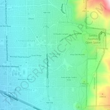
Name: Topografische Karte Monte Largo Hills, Höhe, Relief.
Durchschnittliche Höhe: 1’817 m
Minimale Höhe: 1’683 m
Maximale Höhe: 2’317 m
Spenden
Rüste dich für dein nächstes Abenteuer:
Als Amazon-Partner verdient diese Seite an qualifizierten Käufen, ohne dass Ihnen zusätzliche Kosten entstehen.
Andere topografische Karten
Klicken Sie auf eine Karte, um ihre Topografie, ihre Höhe und ihr Relief anzuzeigen.
Central Pond (Tingley Beach)
United States > New Mexico > Bernalillo County > Albuquerque
Durchschnittliche Höhe: 1’511 m
South Valley
United States > New Mexico > Bernalillo County > Albuquerque
Durchschnittliche Höhe: 1’552 m
Joe M. Lucero Hillside
United States > New Mexico > Bernalillo County > Albuquerque
Durchschnittliche Höhe: 1’637 m