
Spenden
Rüste dich für dein nächstes Abenteuer:
Als Amazon-Partner verdient diese Seite an qualifizierten Käufen, ohne dass Ihnen zusätzliche Kosten entstehen.
Topografische Karte Cosa
Klicken Sie auf die Karte, um die Höhe anzuzeigen.
Spenden
Rüste dich für dein nächstes Abenteuer:
Als Amazon-Partner verdient diese Seite an qualifizierten Käufen, ohne dass Ihnen zusätzliche Kosten entstehen.
Cosa
El relieve del territorio está caracterizado por el Sistema Ibérico turolense, al este de la depresión que forma el río Jiloca. Se encuentra a gran altitud, la cual oscila entre los 1385 metros al suroeste, en la llamada Loma Pedriza, y los 1130 metros al noroeste, a orillas del río de Cosa. El pueblo se alza a 1185 metros sobre el nivel del mar.
Spenden
Rüste dich für dein nächstes Abenteuer:
Als Amazon-Partner verdient diese Seite an qualifizierten Käufen, ohne dass Ihnen zusätzliche Kosten entstehen.
Über diese Karte
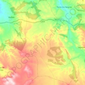
Name: Topografische Karte Cosa, Höhe, Relief.
Ort: Cosa, Jiloca, Teruel, Aragón, España (40.74850 -1.17315 40.86252 -1.07132)
Durchschnittliche Höhe: 1’248 m
Minimale Höhe: 1’045 m
Maximale Höhe: 1’493 m
Spenden
Rüste dich für dein nächstes Abenteuer:
Als Amazon-Partner verdient diese Seite an qualifizierten Käufen, ohne dass Ihnen zusätzliche Kosten entstehen.
Andere topografische Karten
Klicken Sie auf eine Karte, um ihre Topografie, ihre Höhe und ihr Relief anzuzeigen.