
Topografische Karte Judith Gap
Interaktive Karte
Klicken Sie auf die Karte, um die Höhe anzuzeigen.
Über diese Karte
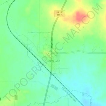
Name: Topografische Karte Judith Gap, Höhe, Relief.
Durchschnittliche Höhe: 1’406 m
Minimale Höhe: 1’386 m
Maximale Höhe: 1’442 m
Because of its topography and prevailing winds, Judith Gap is the site of one of the most ambitious wind power projects in the United States. The 90 wind turbines at the Judith Gap Wind Farm have a nameplate capacity of 135 MW.
Andere topografische Karten
Klicken Sie auf eine Karte, um ihre Topografie, ihre Höhe und ihr Relief anzuzeigen.
Harlowton
United States > Montana > Wheatland County
Harlowton, Wheatland County, Montana, United States
Durchschnittliche Höhe: 1’286 m